Posted on Leave a comment

A Bright Spot at Mount Michael

A small ice- and snow-covered island with an active volcanic crater at its center is surrounded by drifting pieces of sea ice. A thermal signal and small plume appear in the crater, and ash darkens the snow on the volcano’s northern slopes.
Mount Michael on Saunders Island, seen in this image acquired with the OLI (Operational Land Imager) on Landsat 8 on August 24, 2026, hosts a frequently active lava lake in its summit crater.
NASA Earth Observatory/Michala Garrison

Winter near the Antarctic Circle brings months of frozen darkness, when sea ice chokes ocean waters and many of its denizens hunker down to ride out the harsh conditions. But as winter began to release its icy grip, an uncommonly clear satellite image revealed that part of this remote realm was still very much awake, at least volcanically speaking.

Mount Michael, the stratovolcano at the center of Saunders Island, rises above the ice-filled South Atlantic Ocean in this image, acquired with the OLI (Operational Land Imager) on the NASA-USGS Landsat 8 satellite on August 24, 2026. The natural-color image is overlaid with an infrared signal (OLI bands 7-6-5), shown in red, revealing heat from the persistent lava lake in its summit crater. A puff of a volcanic plume hovering over the peak, along with darkened snow on its northern slopes, also suggests ongoing activity.

Saunders Island is one of the South Sandwich Islands, a string of small volcanic peaks about 350 kilometers (220 miles) long that formed from the South American plate subducting beneath the tiny South Sandwich plate. Regular eruptions, including at Mount Michael, have occurred on these islands in recent centuries.

Because of the volcanoes’ remoteness, scientists rely on satellite data to understand their activity. An analysis of thermal anomalies in Landsat, Sentinel, and ASTER (Advanced Spaceborne Thermal Emission and Reflection Radiometer) observations spanning 30 years led researchers to conclude that Mount Michael hosts a persistent lava lake in its summit crater. Only a handful of other volcanoes on Earth, including Kīlauea, Nyamulagira, and Erta Ale, are known to have similar, frequently active features.

Thermal observations from the MODIS (Moderate Resolution Imaging Spectroradiometer) and VIIRS (Visible Infrared Imaging Radiometer Suite) instruments have also enabled long-term monitoring of Mount Michael. Data provided through MIROVA, a near-real-time volcanic hot spot detection system, indicate that low-intensity activity has been ongoing at the volcano for the past several years. Other observations from NASA’s Aura satellite show that emissions of sulfur dioxide and other gases are common at Mount Michael.

A series of V-shaped wave clouds appears over an ocean filled with pieces of sea ice.
Wave clouds form downwind of Saunders Island in this image acquired with the OLI (Operational Land Imager) on Landsat 9 on September 1, 2026.
NASA Earth Observatory/Michala Garrison

The cloud-free window over Mount Michael would close in short order. One week later, when Landsat 9 passed over the island, a more active atmosphere had returned. But the weather patterns interacted with the island to put on a spectacle of their own. The 843-meter-high (2,766-foot-high) peak jutting from the ocean disturbed passing winds to produce a series of wave clouds resembling the wake of a ship, a familiar phenomenon in this region. False-color imagery captured by NASA’s Aqua satellite indicates that a volcanic track caused by degassing sulfur dioxide was likely present as well.

NASA Earth Observatory images by Michala Garrison, using Landsat data from the U.S. Geological Survey. Story by Lindsey Doermann.

References & Resources

You may also be interested in:

Stay up-to-date with the latest content from NASA as we explore the universe and discover more about our home planet.

Ever Restless Mount Dukono Erupts

2 min read

The volcano on Indonesia’s Halmahera Island routinely ejects ash, volcanic gases, and volcanic bombs.
Article

A Sea of Spinning Clouds

3 min read

Icy, isolated Peter I Island stirred up a show in the atmosphere off the West Antarctic coast.

Article

America’s Emerald Isle

3 min read

Beaver Island is one in a string of verdant and scenic jewels in a northern Lake Michigan archipelago.


Article

Source: science.nasa.gov

Posted on Leave a comment

NASA Shares Views of August Solar Eclipse from Ground, Air, Space

3 Min Read

NASA Shares Views of August Solar Eclipse from Ground, Air, Space

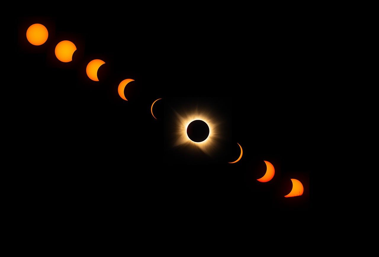
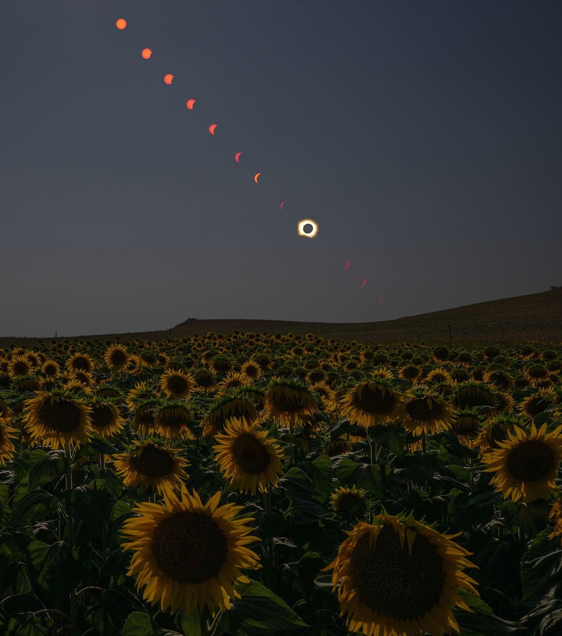
A sequence of images in a diagonal line from upper left to lower right shows the progression of a total solar eclipse, with an uneclipsed Sun in the upper left and other images showing the Sun becoming more and more eclipsed toward the lower right. A total eclipse, with the white corona around the dark disk of the Moon, appears in the line of eclipse images, near the center. Three more images to the lower right of the total eclipse show a crescent Sun becoming less eclipsed. The final image in the lower right shows the Sun starting to dip below the horizon, with its lower portions covered by the foreground.

This composite image shows the progression of a total solar eclipse as the Sun sets over San Millán de los Caballeros, Spain, on Wednesday, Aug. 12, 2026.

Credits:
NASA/Bill Ingalls

On Aug. 12, a total solar eclipse darkened skies over Greenland, Iceland, and Spain. As the Moon covered the Sun, it briefly revealed the Sun’s wispy outer atmosphere — the corona — to those in the path of totality who were lucky enough to have clear skies. NASA researchers and photographers were along the eclipse path to study the corona, capture the phenomenon, and observe how the eclipse affected our planet.

One NASA photographer in Spain captured the total solar eclipse as well as the partial phases before and after, until the Sun set below the horizon.

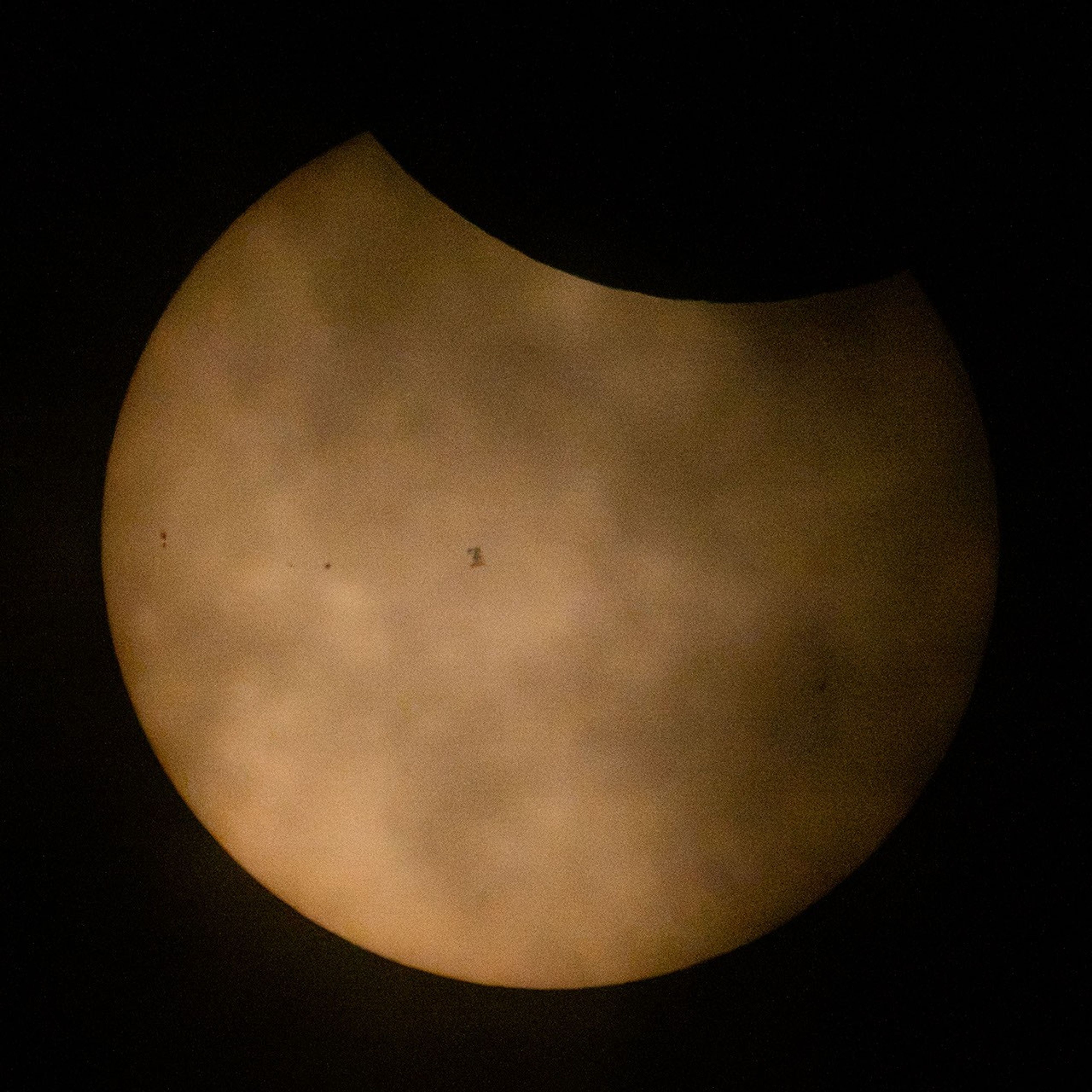
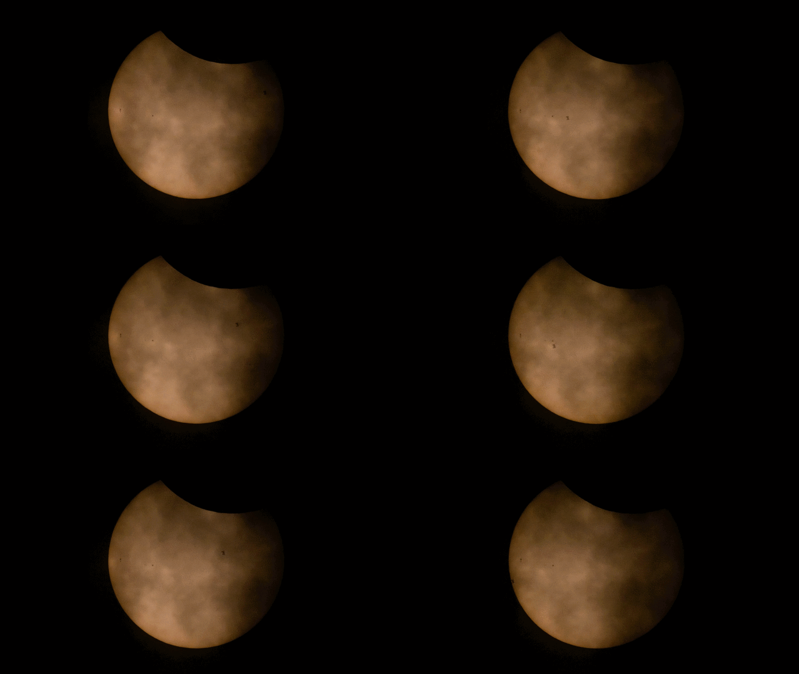
In northern Maine, where only a partial eclipse was visible, another NASA photographer captured the International Space Station, with its crew of seven aboard, speeding past the partially eclipsed Sun.

Meanwhile, from about 250 miles above the ground, a NASA astronaut aboard the International Space Station snapped a few photos of the partial eclipse from their perspective as well.

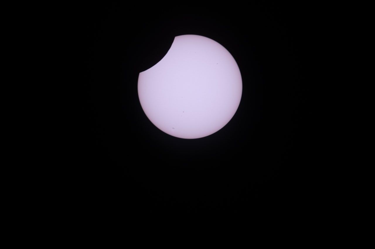
A photo shows the partially eclipsed Sun as a white disk, set against a black sky, with a small
NASA astronaut Jessica Meir captured this photo of the partial solar eclipse from the International Space Station on Aug. 12, 2026, as the orbital outpost soared 262 miles above southern Quebec, Canada. From the station, the Moon covered about 18% of the Sun at the peak of the eclipse. Credit: NASA/Jessica Meir

Between the ground and the space station, NASA pilots flew NASA’s WB-57F research jet at an altitude of 50,000 feet, passing through the eclipse’s shadow to lengthen their time in the eclipse. The jet carried a suite of cameras that captured high-resolution images of the corona and prominences, plumes of electrically charged gas rising off the Sun, in several different wavelengths of light.

The total solar eclipse on Aug. 12, 2026, was captured by a camera mounted inside the cockpit window of NASA’s WB-57F aircraft as it flew around 50,000 feet altitude off the coast of Iceland.
NASA
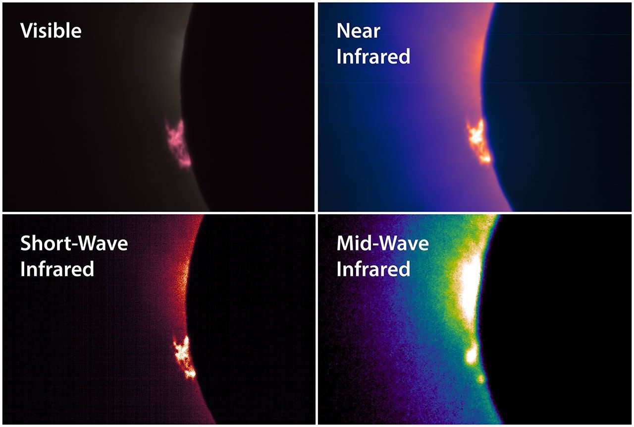
Four panels show the left edge of the eclipsed Sun in different wavelengths of light. In each image is a cloud of material, a prominence, rising off the left edge of the Sun. The prominence appears in different colors and resolutions in each image. The four images are labeled Visible, Near Infrared, Short-Wave Infrared, and Mid-Wave Infrared.
A suite of cameras installed on NASA’s WB-57F aircraft captured images of the solar corona and prominences in different wavelengths of visible and infrared light during the total solar eclipse on Aug. 12, 2026. A science team led by the Southwest Research Institute in Boulder, Colorado, will analyze the images to learn more about complex and dynamic features in the Sun’s outer atmosphere. Credit: NASA/SwRI/Will Ashfield

In both Iceland and Spain, teams of students participating in the NASA-funded Nationwide Eclipse Ballooning Project launched scientific balloons that carried instruments to capture images of the eclipse’s shadow and study the eclipse’s effects on our atmosphere. Even though clouds obscured the view of the eclipse from the ground in Iceland, the weather did not interfere with the balloon-borne instruments’ ability to gather information about how the brief loss of light and heat affected the lower atmosphere.

Four students in jackets hold a large white balloon in a grassy field under a gray, cloudy sky.
Students participating in the NASA-funded Nationwide Eclipse Ballooning Project prepare to launch a scientific balloon in Mosfellsbær, Iceland, during the total solar eclipse on Aug. 12, 2026. Credit: NASA/Abbey Interrante
The Moon’s shadow passes over the atmosphere during the total solar eclipse on Aug. 12, 2026. The video was taken by a camera carried by a scientific balloon launched from Spain by a student team from Montana State University participating in the NASA-funded Nationwide Eclipse Ballooning Project. The video captures about six minutes of time but is sped up to play at four times real speed. Passing through the foreground are some other science instruments carried by the same balloon.
Nationwide Eclipse Ballooning Project/Montana State University

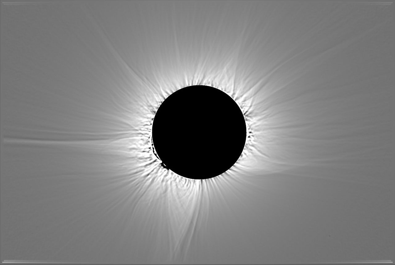
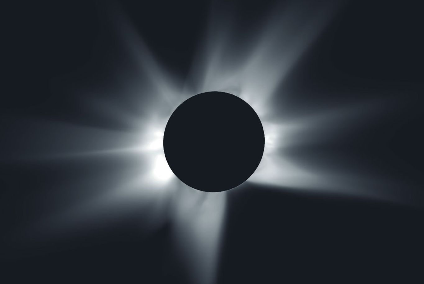
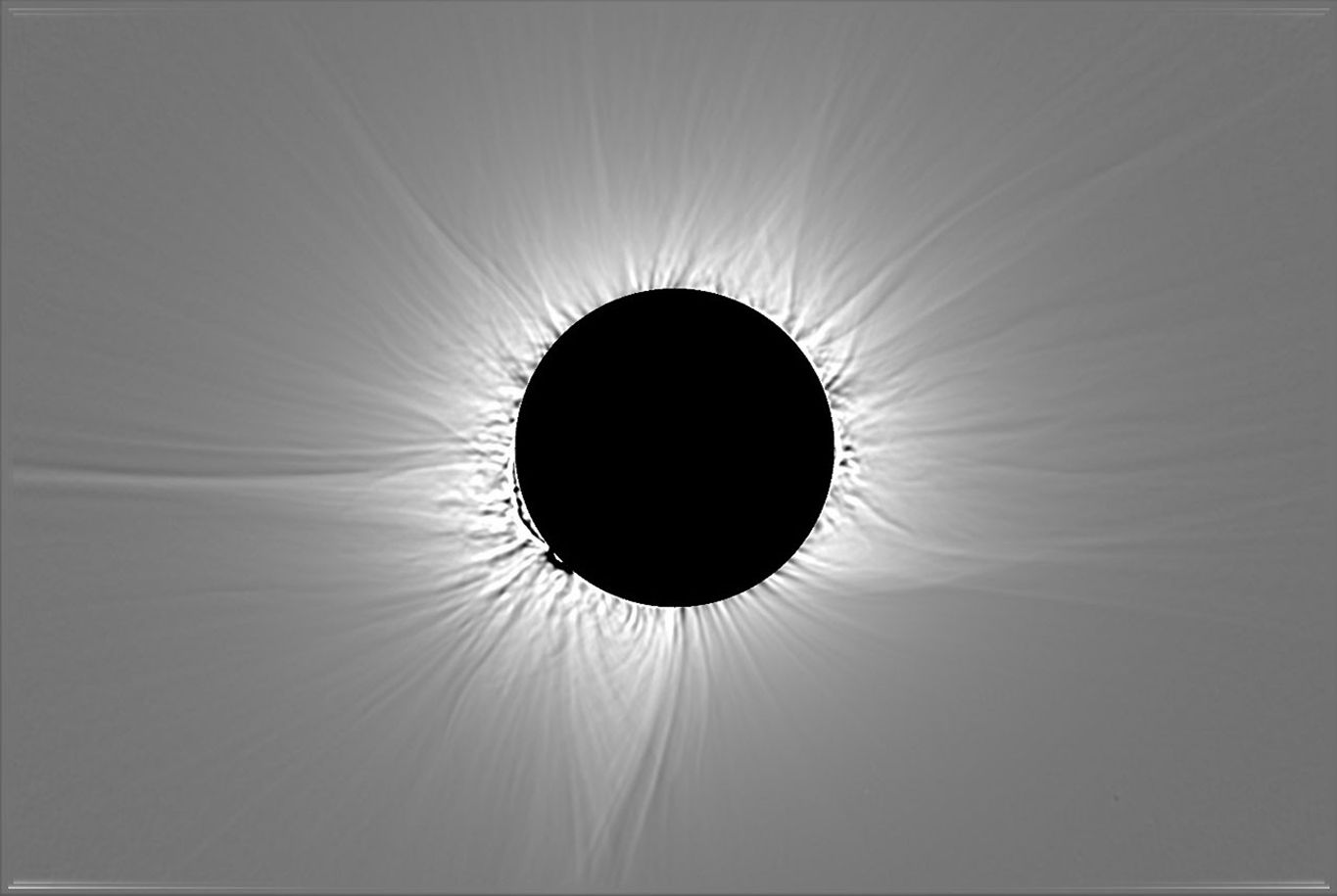
Before the eclipse, scientists at Predictive Science Inc., with support from NASA grants and supercomputers, used observations of the Sun from NASA spacecraft and ground-based telescopes to predict what the corona would look like during the eclipse. Below, their corona prediction is compared to a composite image of the corona, which combines multiple images captured by the NASA-supported DEB Initiative project during the total eclipse near LeĂłn, Spain.


prediction
image

A simulated image of a total solar eclipse shows the Moon as a black disk at the center surrounded by white rays extending outward around the Moon, set against a black background. Some of the rays are longer or thicker than others.
This image shows a prediction from the morning of Aug. 12, 2026, of what the solar corona would look like to the human eye during the total solar eclipse that day.
Predictive Science Inc.

An image of a total solar eclipse shows the Moon as a black disk at the center surrounded by white rays extending outward around the Moon, set against a gray background. Some of the rays are longer or thicker than others.
This processed, composite image of the corona combines multiple images captured near LeĂłn, Spain, during the total solar eclipse on Aug. 12, 2026.
DEB Initiative Team/Zack Stockbridge

A simulated image of a total solar eclipse shows the Moon as a black disk at the center surrounded by white rays extending outward around the Moon, set against a black background. Some of the rays are longer or thicker than others.
This image shows a prediction from the morning of Aug. 12, 2026, of what the solar corona would look like to the human eye during the total solar eclipse that day.
Predictive Science Inc.

An image of a total solar eclipse shows the Moon as a black disk at the center surrounded by white rays extending outward around the Moon, set against a gray background. Some of the rays are longer or thicker than others.
This processed, composite image of the corona combines multiple images captured near LeĂłn, Spain, during the total solar eclipse on Aug. 12, 2026.
DEB Initiative Team/Zack Stockbridge


prediction

image


The left image shows a prediction from the morning of Aug. 12, 2026, of what the solar corona would look like to the human eye during the total solar eclipse that day. The right image is processed, composite image of the corona that combines multiple images captured near LeĂłn, Spain, during the total solar eclipse on Aug. 12, 2026. Left image credit: Predictive Science Inc.; right image credit: DEB Initiative Team/Zack Stockbridge

Over the coming months, scientists will analyze the observations and images captured during the solar eclipse on Aug. 12 and present what they have learned about the Sun and its effects on our home planet. These observations will also help prepare science teams to investigate future solar eclipses, such as a much longer total solar eclipse that will be visible from southern Spain and northern Africa on Aug. 2, 2027.

Read more about NASA’s research during the eclipse and rewatch NASA’s eclipse broadcast to hear from some of the scientists and students who conducted the experiments.

About the Author

Vanessa Thomas

Vanessa Thomas

Vanessa Thomas is a science writer with the heliophysics communications team at NASA’s Goddard Space Flight Center in Greenbelt, Maryland.

Details

Last Updated

Aug 21, 2026

Source: science.nasa.gov

Posted on Leave a comment

NASA Johnson Pilots Chase Moon’s Shadow for Eclipse Science 

3 Min Read

NASA Johnson Pilots Chase Moon’s Shadow for Eclipse Science 

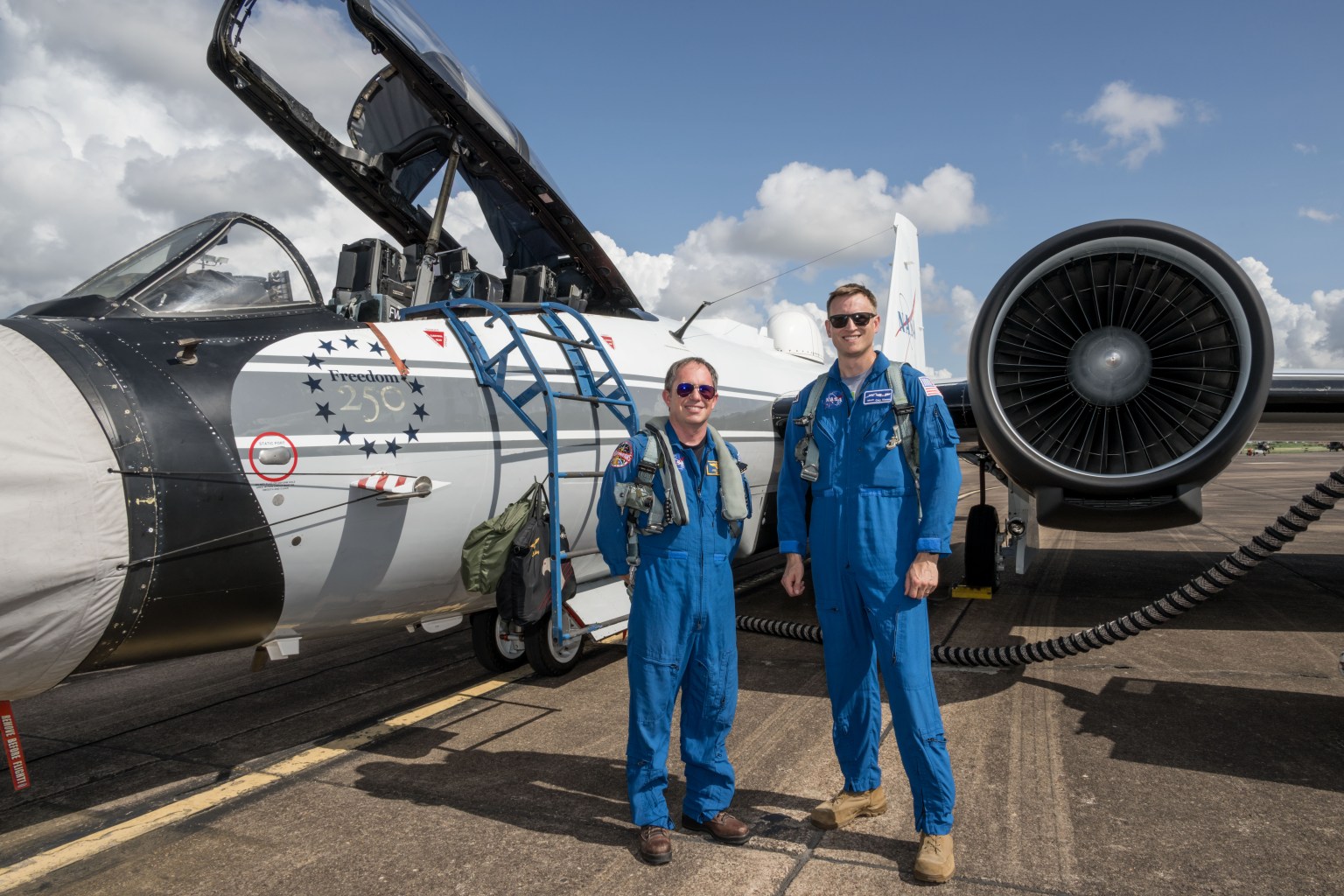
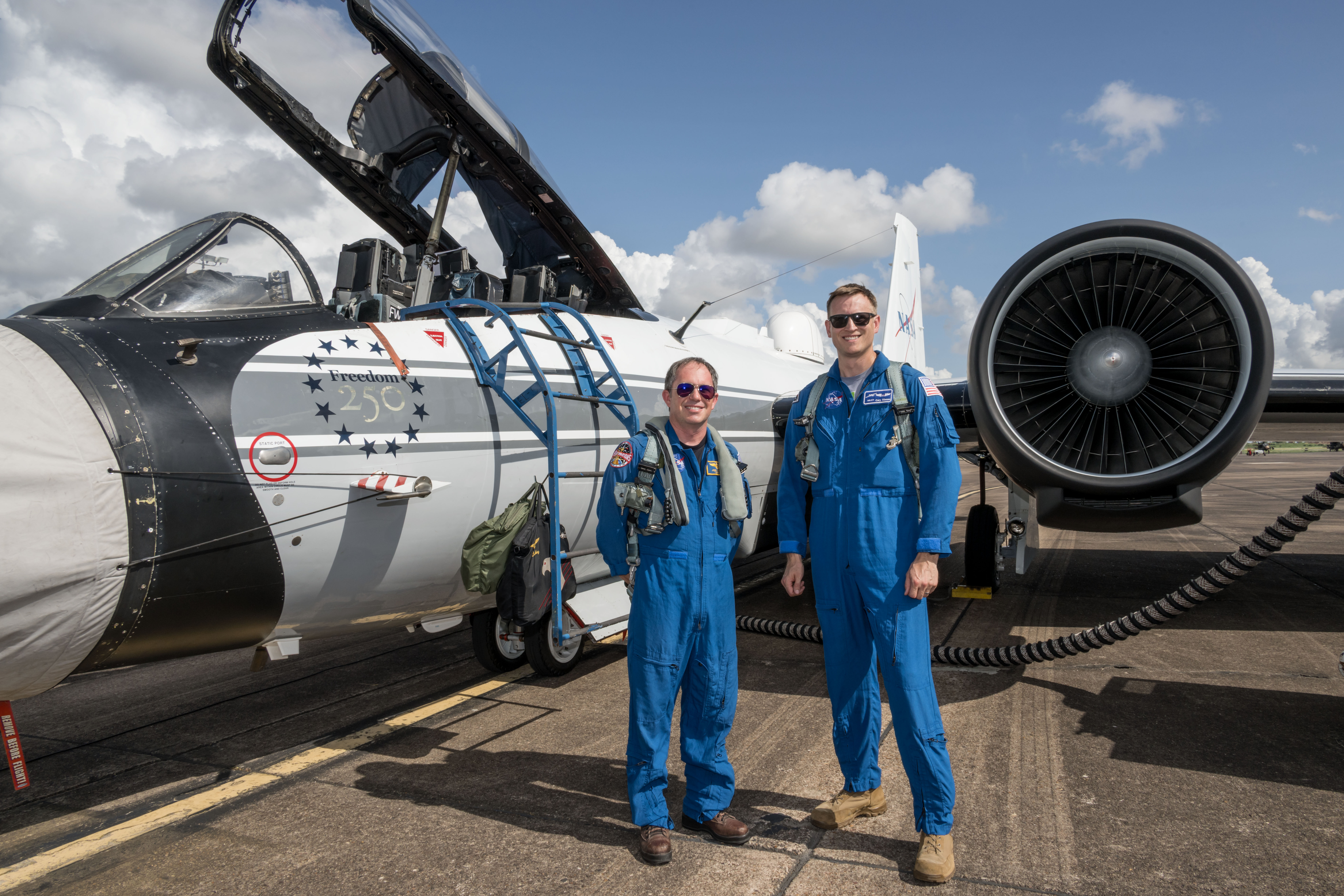
NASA’s WB-57F aircraft prepares for takeoff from Ellington Field in Houston ahead of its mission to observe the Aug. 12, 2026, total solar eclipse from Iceland. From left are John Gustine, NASA WB-57F pilot, and Cary Klemm, sensor equipment operator for NASA’s WB-57F.
NASA/Robert Markowitz

During the Aug. 12 total solar eclipse over Europe, scientists aimed to study a long-standing mystery: why the Sun’s outer atmosphere, the corona, is far hotter than its visible surface. Capturing the data they needed meant being in exactly the right place at the right time. 

Pilots from NASA’s Johnson Space Center flew the WB-57F high altitude research aircraft from Ellington Field in Houston to Iceland, their base for flying through the path of totality to give scientists a clearer view of the Sun’s corona. 

A total solar eclipse provides a unique opportunity to examine the corona because the Moon temporarily blocks the Sun’s bright surface, revealing its fainter outer atmosphere. Observations collected during this brief window can help scientists better understand how energy and material move through the corona and away from the Sun, improving our understanding of space weather. 

John Gustine, NASA WB-57F pilot, prepares for flight at Ellington Field in Houston ahead of the aircraft’s departure for Iceland to support the Aug. 12 total solar eclipse.
NASA/Robert Markowitz

At about 50,000 feet, the WB-57F flew above most clouds, dust, and water vapor that can interfere with observations from the ground. The altitude reduced atmospheric interference while also allowing the science instruments to observe infrared wavelengths that are largely absorbed lower in Earth’s atmosphere. 

Capturing those observations required careful coordination between scientists and the flight crew. Before the mission, teams calculated where the aircraft needed to be as the Moon’s shadow moved across the North Atlantic.  

“Going into a mission like this takes a huge team. It starts with the science team establishing the requirements, and then we work closely with them for months leading up to the mission,” said Tom Parent, NASA WB-57F pilot. “We rely heavily on our maintenance team to get the instruments serviced, prepared, loaded onto the aircraft, and flight tested. It’s a huge team effort to get an aircraft like this up there to image and achieve these objectives.” 

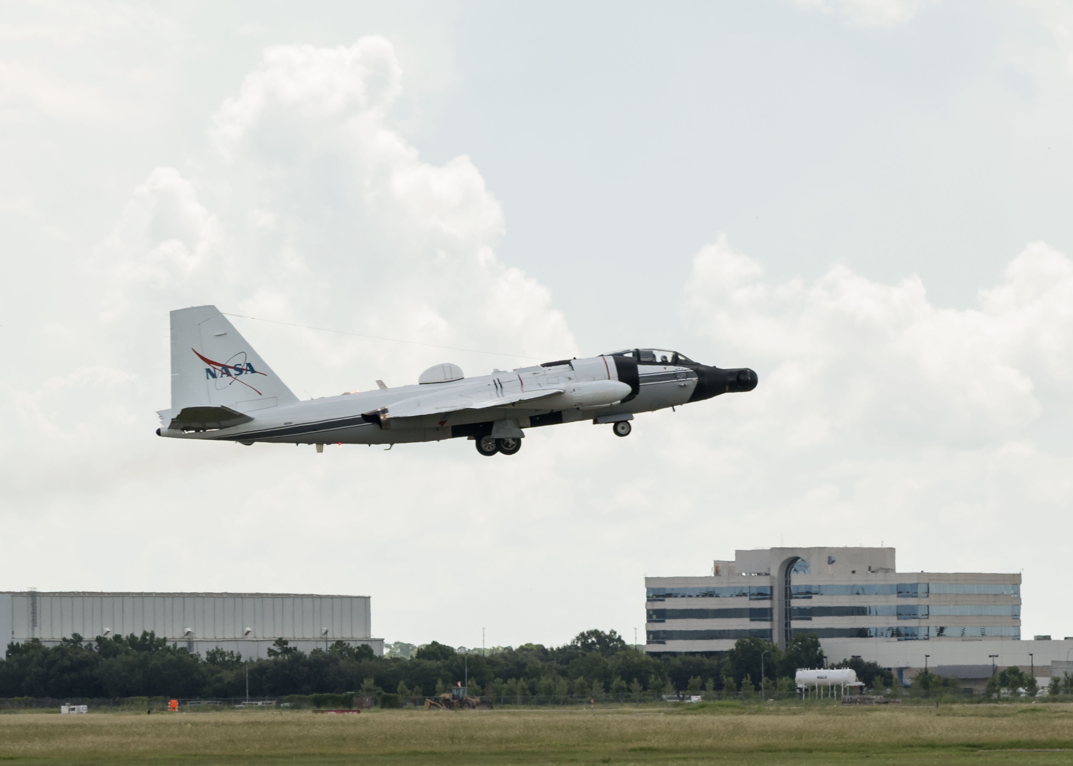
NASA’s WB-57F aircraft takes off from Ellington Field in Houston ahead of its mission supporting the Aug. 12 total solar eclipse from Iceland.
NASA/Robert Markowitz

During totality, NASA WB-57F pilot John Gustine positioned the aircraft along the eclipse path to maximize time in the Moon’s shadow and give scientists as much opportunity as possible to collect data. 

From the back seat, Cary Klemm, sensor equipment operator for NASA’s WB-57F, controlled the camera systems, adjusting focus and exposure times while tracking features of interest throughout totality. 

With the cameras capturing observations throughout the brief window, every second mattered. 

“Every image is another piece of data that could reveal something new about the Sun,” Klemm said. 

What scientists can learn from those observations reaches far beyond the eclipse itself. The Sun’s corona is made of plasma shaped by magnetic fields, and many of the same physical processes occur elsewhere in the universe. 

“The NASA WB-57F’s unique capabilities of high-altitude flight were truly crucial in providing access to these valuable wavelengths during an eclipse whose path crossed mostly over the ocean in an area where clouds are common,” said Amir Caspi, principal investigator for the study at Southwest Research Institute in Boulder, Colorado. “We could not have achieved this success without this platform, and all of the efforts of the many intrepid ground, air, and science crew members.”

Members of NASA’s WB-57F eclipse mission team gather at Ellington Field in Houston ahead of the aircraft’s departure for Iceland.
NASA/Robert Markowitz

The data gathered during the flight will give scientists another opportunity to investigate the Sun and the processes that influence the space environment around Earth. 

View images and videos from NASA’s eclipse mission. 

About the Author

Sumer Loggins

Sumer Loggins

Source: www.nasa.gov

Posted on Leave a comment

What’s Up: September 2026 Skywatching Tips from NASA

Brilliant Venus and a Harvest Moon

Use the Moon to find Antares and the Teapot, spot brilliant Venus, welcome the equinox, and see the Harvest Moon near Saturn and Neptune.

Skywatching Highlights

  • Sept. 14-20: Use the Moon to find Antares and the Teapot; dark skies may reveal the Milky Way center
  • Sept 18: Venus reaches peak brilliance for this evening appearance
  • Sept. 22: September equinox; fall begins in the Northern Hemisphere and spring in the Southern Hemisphere
  • Sept. 26: Harvest Moon rises near Saturn and Neptune
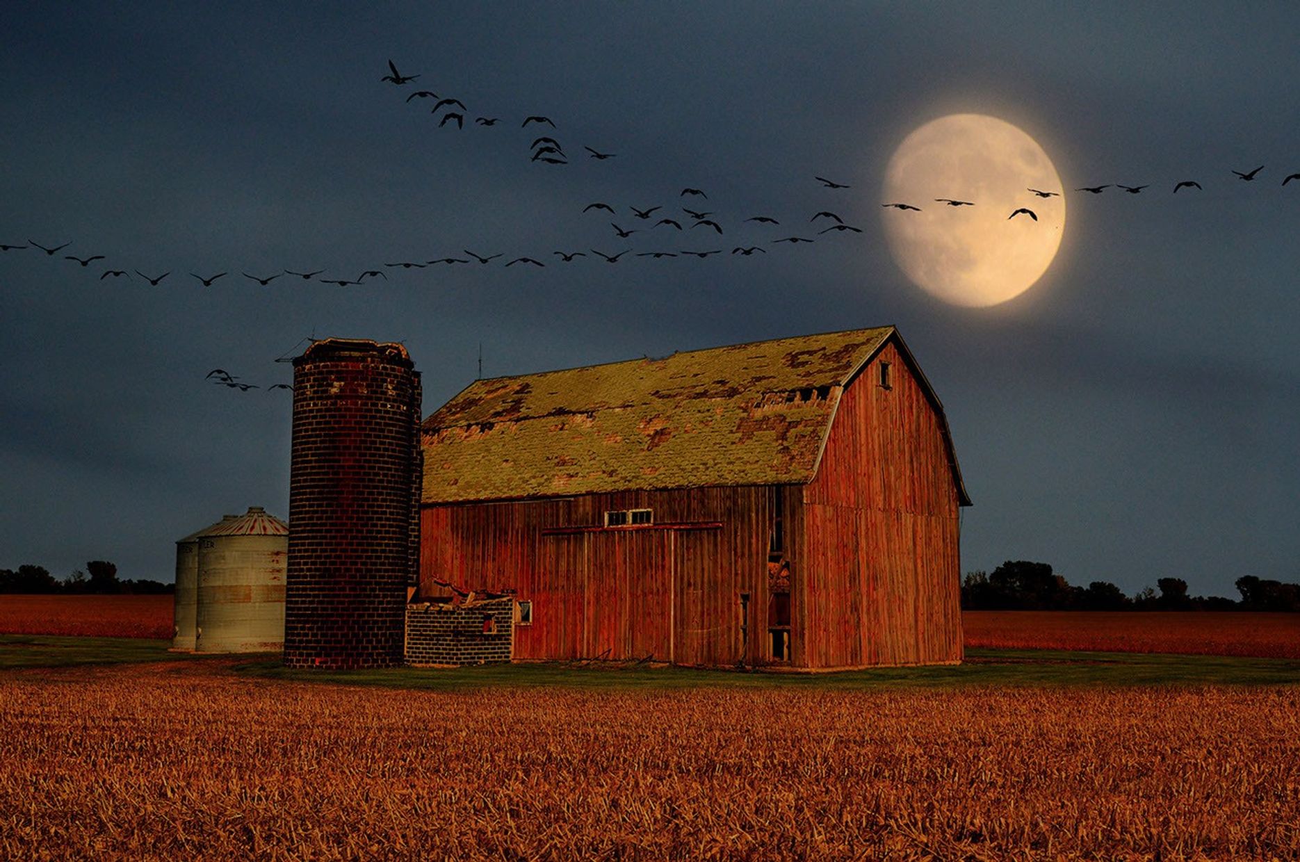
A large, glowing full moon shines bright yellow in a dark twilight sky above a rustic red barn and silo set behind a golden harvest field, with a long V-formation of birds flying across the sky.
Birds fly over a barn as a harvest Moon rises.
Mike Linnihan

Transcript

The Moon joins a tea party… Venus cranks up the brightness… the seasons officially change… and the Harvest Moon meets up with some planetary neighbors.

That’s What’s Up for September.

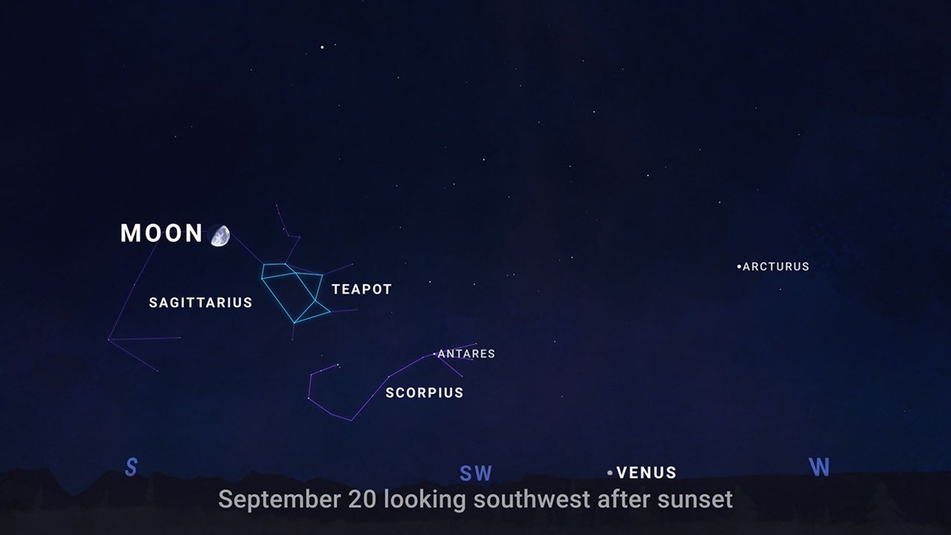
A sky chart looking southwest after sunset on Sept. 20, 2026.
NASA/JPL-Caltech

From September 14 through 20, let the Moon guide you to a few celestial landmarks. About an hour after sunset, look south to find the Moon in the evening sky.

Night by night, the Moon shifts position against the background stars, passing near Antares.

This bright, reddish star marks the heart of the constellation Scorpius.

Next you’ll see the Teapot, a group of stars in neighboring Sagittarius that really does resemble a teapot, complete with a handle, lid, and spout.

If you are under an especially dark sky… you may see hazy steam rising from the Teapot’s spout.
Follow that steam to its thickest part, and you’ll be looking toward the center of our Milky Way galaxy.

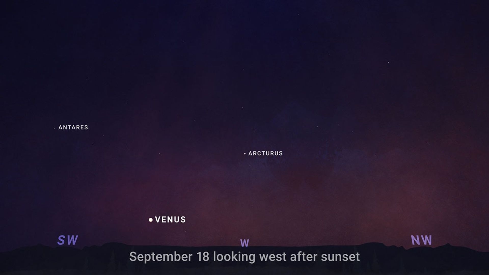
A sky chart looking west after sunset on Sept. 18, 2026.
NASA/JPL-Caltech

Look west on September 18 as Venus hits peak brilliance, shining at its brightest of this evening appearance..

You won’t have to search hard to find it. Shortly after sunset, Venus will stand out as a brilliant point of light low above the western horizon, outshining every star around it. A clear view of the horizon will give you the best chance to catch it before it sets.

On September 19, celebrate International Observe the Moon Night!

People around the world are invited to look up and connect with our nearest celestial neighbor while learning more about lunar science, exploration, and the many ways the Moon has shaped cultures around the world. Find an event near you — or learn how to participate from wherever you are — at go.nasa.gov/ObserveTheMoon.

Then on September 22, it’s officially fall in the Northern Hemisphere …while spring begins in the Southern Hemisphere.

That’s the September equinox, when the Sun is directly above Earth’s equator and day and night are close to equal in length around the world.

From there, daylight keeps getting shorter in the Northern Hemisphere and longer in the Southern Hemisphere.

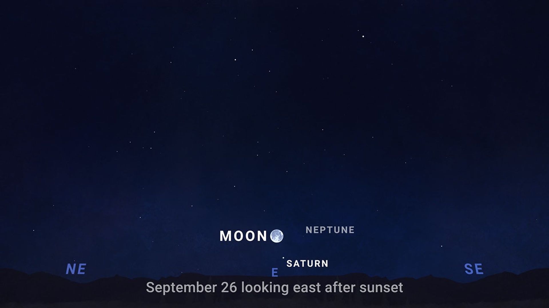
A sky chart looking east after sunset on Sept. 26, 2026.
NASA/JPL-Caltech

And on September 26, the Harvest Moon takes center stage, rising in the east shortly after sunset.

It won’t be alone. Saturn appears nearby, with faint Neptune completing a wide triangle in the sky.

Saturn is the easy one-you can see it with just your eyes. Neptune is a bit more challenging. At around magnitude 8, it’s too faint to see with the unaided eye …so you’ll need binoculars or a telescope to spot it. Darker skies and good observing conditions can help bring it into view.

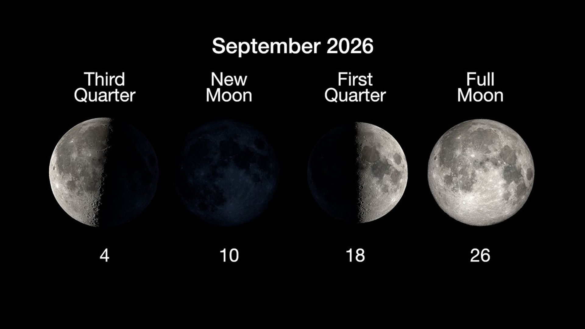
Here are the phases of the Moon for September.

The phases of the Moon for September 2026.
NASA/JPL-Caltech

You can stay up to date on all of NASA’s missions exploring the solar system and beyond at NASA Science. I’m Raquel Villanueva from NASA’s Jet Propulsion Laboratory, and that’s What’s Up this month.

Source: science.nasa.gov
Posted on Leave a comment

Taking Flight to Prepare for Space

Two people in slim yellow spacesuits and white helmets climb into an airplane as technicians work around them.
NASA/Josh Valcarcel

NASA astronaut Adam Fuhrmann (right, in yellow) prepares for a training flight aboard NASA’s WB-57 aircraft in this July 16, 2026, photo.

These high-altitude flights train the crew to work in a tight environment and operate aircraft systems while in a pressure suit, preparing them for future missions to the International Space Station, Moon, or beyond.

Image credit: NASA/Josh Valcarcel

Source: www.nasa.gov