The latest addition to the 100th Security Forces Squadron’s military working dog pack is 3-year-old Mmoab, a black Belgian Malinois who joined the U.S. Air Force canine team at Royal Air Force Mildenhall, England.
Source: www.war.gov
The latest addition to the 100th Security Forces Squadron’s military working dog pack is 3-year-old Mmoab, a black Belgian Malinois who joined the U.S. Air Force canine team at Royal Air Force Mildenhall, England.
Source: www.war.gov
Delegates to the Second Continental Congress adopted the Declaration of Independence on July 4, 1776. Three of the 56 delegates who signed the formal break from Britain represented New Hampshire: Josiah Bartlett, Matthew Thornton and William Whipple.
Source: www.war.gov
High above Earth, thin veils of metallic haze drift through the edge of space. Known as sporadic E layers, these high-altitude “clouds” form from the vaporized dust of burnt-up meteors, earning their name from the unpredictable way they emerge and then dissipate. Now, new results from a NASA sounding rocket — a suborbital research rocket — that flew five detectors through one of these layers simultaneously reveal unexpected complexity in the layer for the first time.
Though invisible to the eye, sporadic E layers make their presence known to the radio signals we rely on for long-distance communication. When present, sporadic E can send those signals ping-ponging off in unexpected directions, rendering the technology temporarily unreliable.
Scientists have long sought a fuller understanding of these radio-disrupting clouds, but until recently, they had only sampled them one narrow slice at a time. The rocket, called the sporadic E Electrodynamics Demonstration, or SpEED Demon for short, launched from NASA’s Wallops Flight Facility in Virginia on Aug. 24, 2022, and demonstrated the first concurrent, multi-point view inside sporadic E. Its results, from a team led by Embry-Riddle Aeronautical University, are described in a new study in the Journal of Geophysical Research: Space Physics.
Sporadic E layers form in the ionosphere, a region of the upper atmosphere beginning around 40 miles (60 kilometers) up where the neutral gases begin to transform into plasma, or ionized gas. Some of the particles there come from meteors, which burn up and leave behind traces of iron, magnesium, and other metals. These metals occasionally clump into dense, cloud-like sheets — the sporadic E layers — that reflect radio waves.
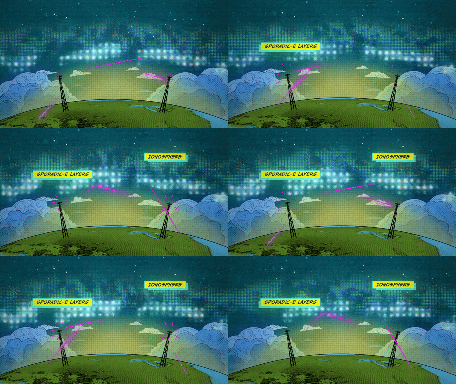
“Sporadic E layers are, in one sense, giant mirrors of radio frequency waves in the sky,” said Aroh Barjatya, the mission’s principal investigator and a professor of engineering physics at Embry-Riddle in Daytona Beach, Florida.
When a sporadic E layer forms, signals meant to travel out to space can ricochet back toward the ground. Air traffic controllers and marine radio users may pick up distant transmissions as though they were nearby, and radars scanning beyond the horizon can register so-called “ghosts,” or false targets. The effects reach everyday technology, too.
“The biggest source of error in the GPS in your phone, for example, is from the plasma in the ionosphere, and sporadic E layers can contribute to this uncertainty,” said Henry Valentine, the study’s lead author, who conducted the work at Embry-Riddle and is now a researcher at the U.S. Naval Research Laboratory.
Because sporadic E layers hover around 60 miles (100 kilometers) up—too high for weather balloons, too low for satellites — and form and dissipate unpredictably, they have long been the province of sounding rockets, which can be launched on short notice to catch one in the act. But a single rocket flies a single path, taking measurements only along a line. Barjatya likens the situation to viewing a scene through a crack in a wall. One can only observe what is happening along that narrow slit, missing out on the crucial context of whatever is occurring to the left or right of one’s view.
The SpEED Demon mission changed that. The mission was the first to deploy ejectable probes, called dropsondes, inside a sporadic E layer. Once inside, the rocket released four dropsondes that flew away from the main payload and from one another, each measuring the plasma along its own track and beaming its measurements back to ground stations. Together with the main payload, the probes sampled the layer in a total of five places at the same moment.
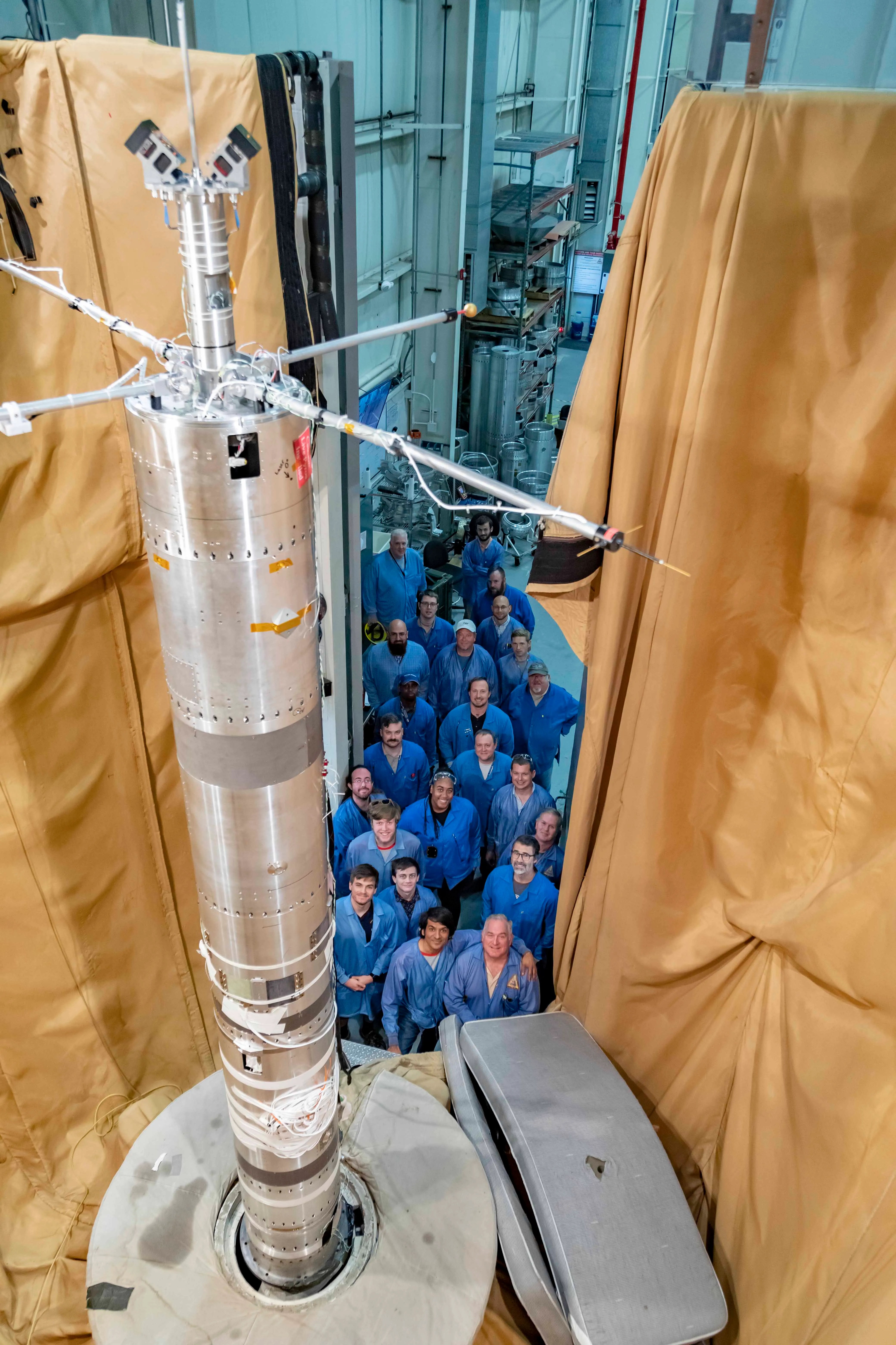
“Now with multiple sensors, we’ve turned that crack into a picket fence,” Barjatya said.
The data revealed surprising complexity inside the sporadic E layer. Rather than a smooth, dense pancake of metallic particles, the layer that SpEED Demon flew through appeared uneven and structured, shaped by turbulent winds moving through the neutral air around it.
“A lot of times you think of sporadic E as this single sharp density layer, but what we saw in ours is it’s interacting with neutral wind and these swirling atmospheric turbulences,” Valentine said. “Rather than a flat pancake, it’s closer to a cinnamon roll.”
On the way down, the layer even split into two distinct peaks. The team found that shape was consistent with modulation by Kelvin-Helmholtz billows, the curling, wave-like instability that produces breaking-wave patterns in ordinary clouds. Because the flight was unable to measure the local winds and electric fields directly, the researchers are careful to call the billow explanation plausible rather than confirmed.
The SpEED Demon mission was designed as a technology demonstration — a test of whether the dropsonde technique would work at all. It did, and the team was quick to apply it again. Barjatya’s team used a similar multi-probe strategy to launch rockets into the paths of the October 2023 annular eclipse and April 2024 total solar eclipse, studying how the sudden darkness disturbed the upper atmosphere. In June 2025, they flew SpEED Demon’s most direct descendant, Sporadic-E ElectroDynamics, or SEED, into sporadic E layers from Kwajalein Atoll in the Marshall Islands, studying them at lower latitudes. Papers from those missions are in preparation.

After years of study, sporadic E layers are no longer as unpredictable as they once were. “They have a seasonality to them, with peak occurrence happening in the local summer,” Barjatya said.
Questions about how and when they form are increasingly fine-grained. The new deployable multi-point rocket sensor methodology, along with ground-based measurements, is likely to bring the picture even closer to completion. “The science community as a whole is now in its final stretches of fully understanding these giant radio frequency mirrors in the sky,” Barjatya said.
By Miles Hatfield
NASA’s Goddard Space Flight Center, Greenbelt, Md.

Source: science.nasa.gov
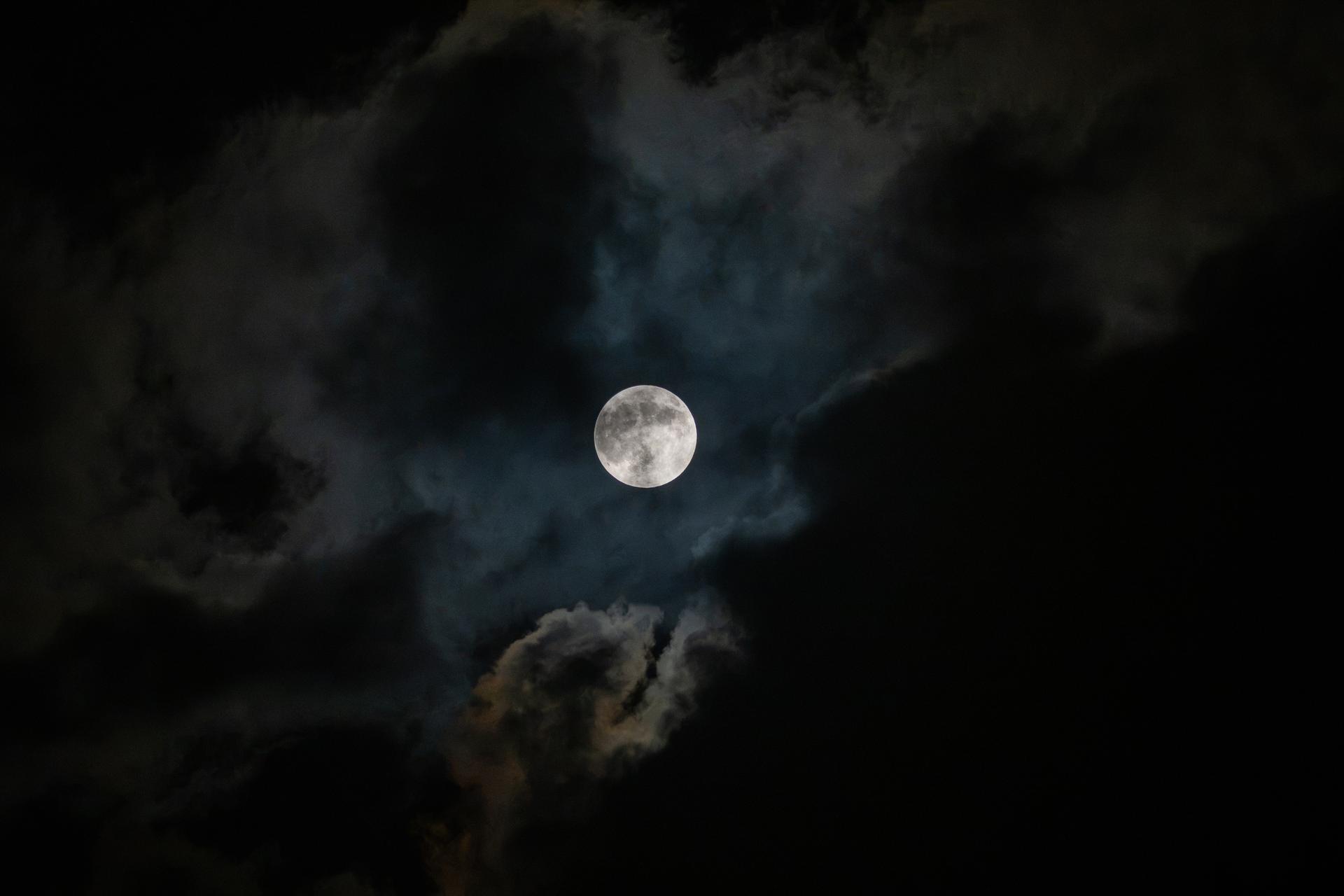
On Aug. 28, 2026 (the evening of Aug. 27 in some time zones), the Moon passed into Earth’s shadow, creating a deep partial lunar eclipse. At the moment of greatest eclipse, 12:13 a.m. EDT, 96.3% of the Moon’s disk was immersed in Earth’s umbra—the central, darkest part of the shadow where sunlight is completely blocked. This stage of the eclipse was visible across much of the Americas (except Alaska and northwestern Canada), as well as western Europe and western Africa.
This image of the eclipse was captured in southern Louisiana, home to NASA’s Michoud Assembly Facility—the nation’s premier site for manufacturing and assembling large-scale space structures and systems, including the core stages of the Space Launch System (SLS) rocket powering the Artemis program.
Source: www.nasa.gov
5 min read
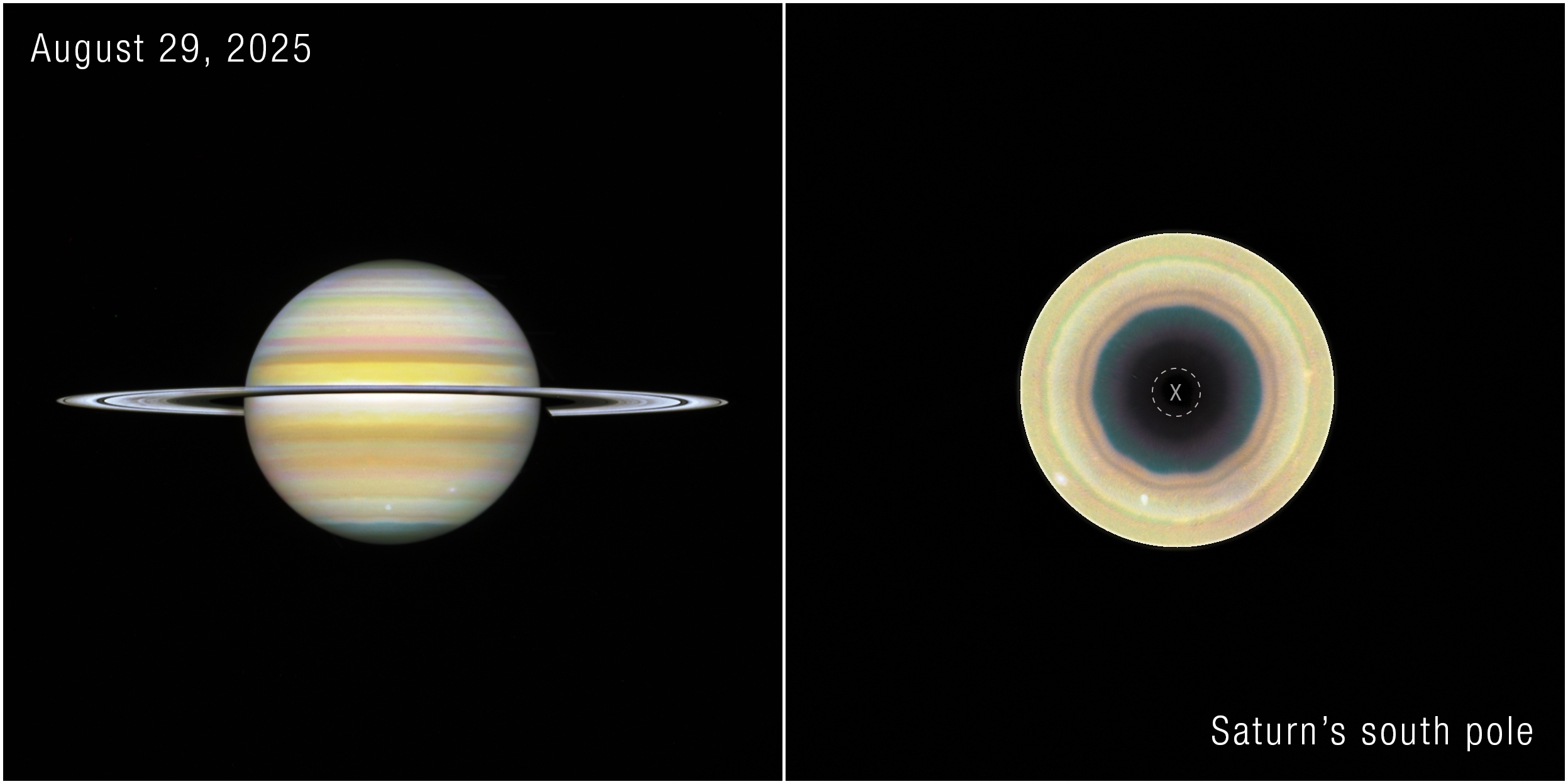
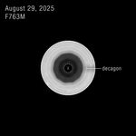
Recent observations with NASA’s Hubble Space Telescope have revealed a giant, evolving, 10-sided atmospheric wave encircling Saturn’s south pole. This discovery marks the first time a large, regular-sided jet pattern has been observed in the planet’s southern hemisphere. The feature appears remarkably similar to Saturn’s famous hexagon at its northern pole, but is also distinctly different, suggesting scientists may be witnessing a new atmospheric phenomenon develop on the iconic gas giant.
The results published Wednesday in the journal Science Advances.
By piecing together several years of Hubble observations dating back to 2023, researchers found subtle hints of the structure beginning to emerge before it became a clearly defined pattern. Those observations were taken as part of Hubble’s Outer Planet Atmospheres Legacy (OPAL) program, which has photographed the outer planets annually for more than a decade.
“We’ve never seen anything quite like this in Saturn’s southern hemisphere,” said Amy Simon, study co-author and OPAL principal investigator, NASA’s Goddard Space Flight Center in Greenbelt, Maryland. “The northern hexagon has been there every time we’ve looked for more than 40 years. This feature is different — it appears to be strengthening, giving us the rare opportunity to watch a giant atmospheric pattern develop.”
The discovery was possible because Saturn’s changing seasons gradually brought the planet’s south pole back into view from Earth, where astronomers who collectively analyze images of Saturn from ground-based observatories first identified it.
Agustín Sánchez-Lavega, lead author of the new study, is a researcher at the University of the Basque Country in Spain. The university manages a website, called Planetary Virtual Observatory Laboratory, that accepts ground-based images of solar system planets contributed by observers all over the world. It was in those images, first in 2024, that Sánchez-Lavega and amateur astronomers Trevor Barry and Jean-Paul Oger noticed a subtle undulating band along the southern pole. Additional 2025 imagery taken from the ground hinted even more strongly toward this decagon structure.
That’s when the Hubble observations come into the picture. Hubble’s view from space offers unmatched image sharpness and spatial resolution over full rotations of Saturn, without smearing by Earth’s atmosphere.
“Given Saturn’s symmetry in its north-south jet stream system, we have been searching for a counterpart to Saturn’s northern hexagon on the south pole in Hubble images since 1990,” Sánchez-Lavega said. “Images from NASA’s Cassini spacecraft, which orbited Saturn between 2004 and 2017, showed no inkling of a long-lived formation, either. The Hubble data confirmed the feature’s presence back to 2023.”
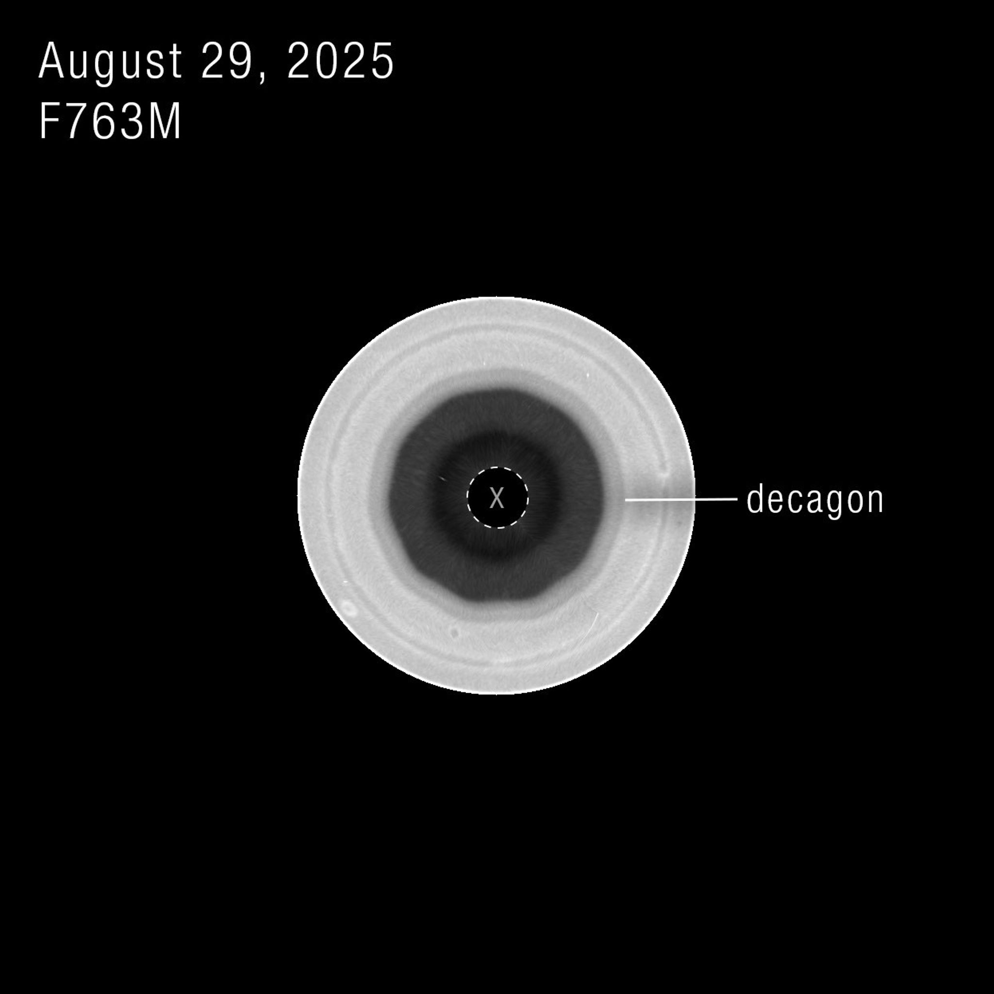
The wave sits within one of Saturn’s powerful jet streams and extends through multiple layers of the atmosphere, indicating it is not just a cloud-level feature, but a vertically extended atmospheric structure. The decagon’s apparent position shifts slightly, because Hubble captures images from different wavelengths. Those different wavelengths probe different altitudes in Saturn’s atmosphere.
“The most intriguing part to me is that this seems to have just formed recently,” said Simon. “The question is, why did it suddenly form now when we haven’t seen one before?”
The authors say further study is needed from Hubble and NASA’s James Webb Space Telescope, as well as analysis of computer models, to understand how the decagon formed, how long it may last, and how it compares to the long-lived hexagon in the north.
Hubble’s long duration in operation has allowed astronomers to track changes over time in solar system planets and other astronomical objects as well.
Rather than providing a single snapshot, the OPAL program allows scientists to follow seasonal changes, track short-lived storms, and identify other atmospheric features that evolve slowly over time.
“When we started the OPAL program, we expected compelling surprises, but we didn’t know what to expect specifically,” said Mike Wong, study co-author, University of California, Berkeley. “A lot of the discoveries we see coming from OPAL are not just based on one observation, but on years and years of data. Regular observations over time are enabling a lot of new findings.”
The team plans to continue observing Saturn to determine whether the decagon settles into a long-lived, stable configuration like the northern hexagon or continues to evolve. Future observations also could help scientists determine what drives the wave, what it reveals about the atmospheric dynamics of giant planets throughout the solar system, and how they may relate to those we see here on Earth.
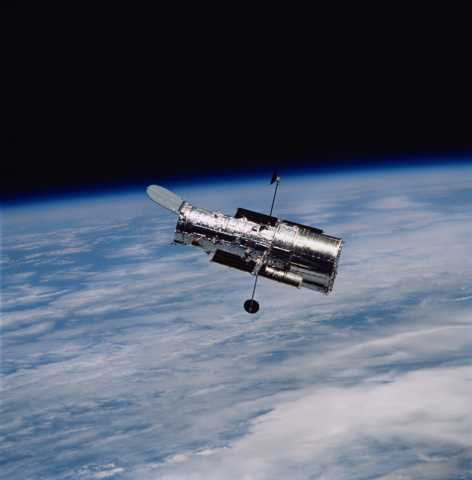
The Hubble Space Telescope has been operating for more than three decades and continues to make ground-breaking discoveries that shape our fundamental understanding of the universe. Hubble is a project of international cooperation between NASA and ESA (European Space Agency). NASA’s Goddard Space Flight Center in Greenbelt, Maryland, manages the telescope and mission operations. Lockheed Martin Space also supports mission operations at Goddard. The Space Telescope Science Institute in Baltimore, which is operated by the Association of Universities for Research in Astronomy, conducts Hubble science operations for NASA.
Claire Andreoli
NASA’s Goddard Space Flight Center
Greenbelt, Maryland
[email protected]
Hannah Braun
Space Telescope Science Institute
Baltimore, Maryland
Source: science.nasa.gov
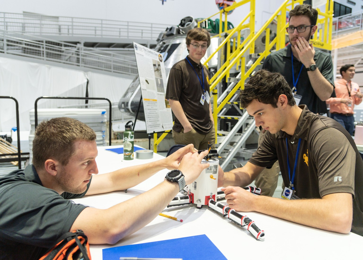
Community college students across the U.S. now have another opportunity to discover how their education can lead to fulfilling roles at the forefront of aerospace, science, engineering, and technology. The updated NASA Community College Aerospace Scholars (NCAS) student challenge invites students to learn about the agency and its missions, engage with NASA experts, and explore aerospace jobs while competing for monetary awards.
The applications period is currently open. The deadline to register is Monday, Sept. 28.
“What makes this opportunity unique is that it’s one of few that is specifically for community college students,” said Alicia Baturoni Cortez, project manager for NASA’s Minority University Research and Education Project, which administers NCAS. “The NCAS student challenge is designed to meet their needs and broaden their career awareness so they can either go right into the workforce or expand their goals to include a four-year degree in STEM.”
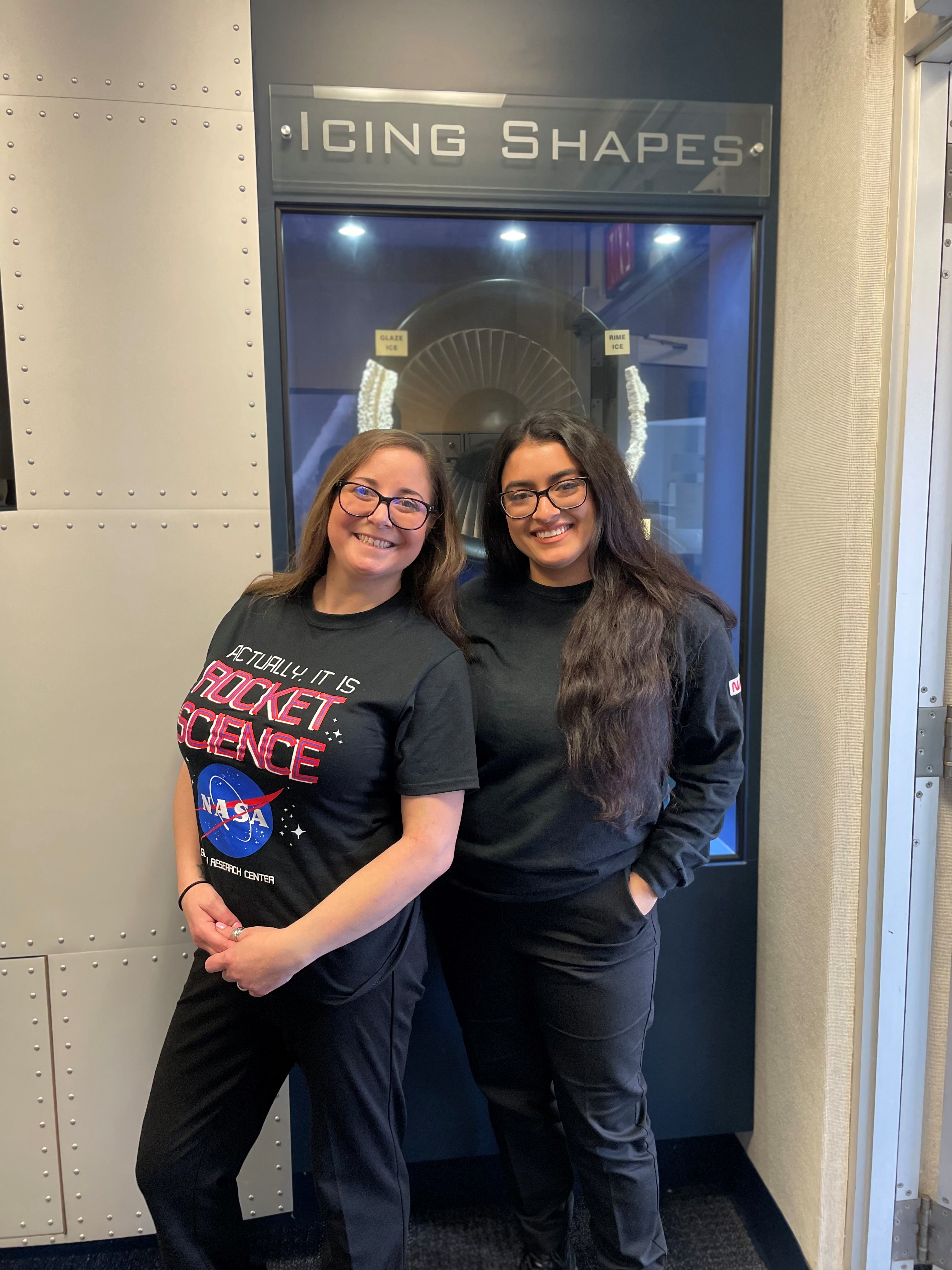
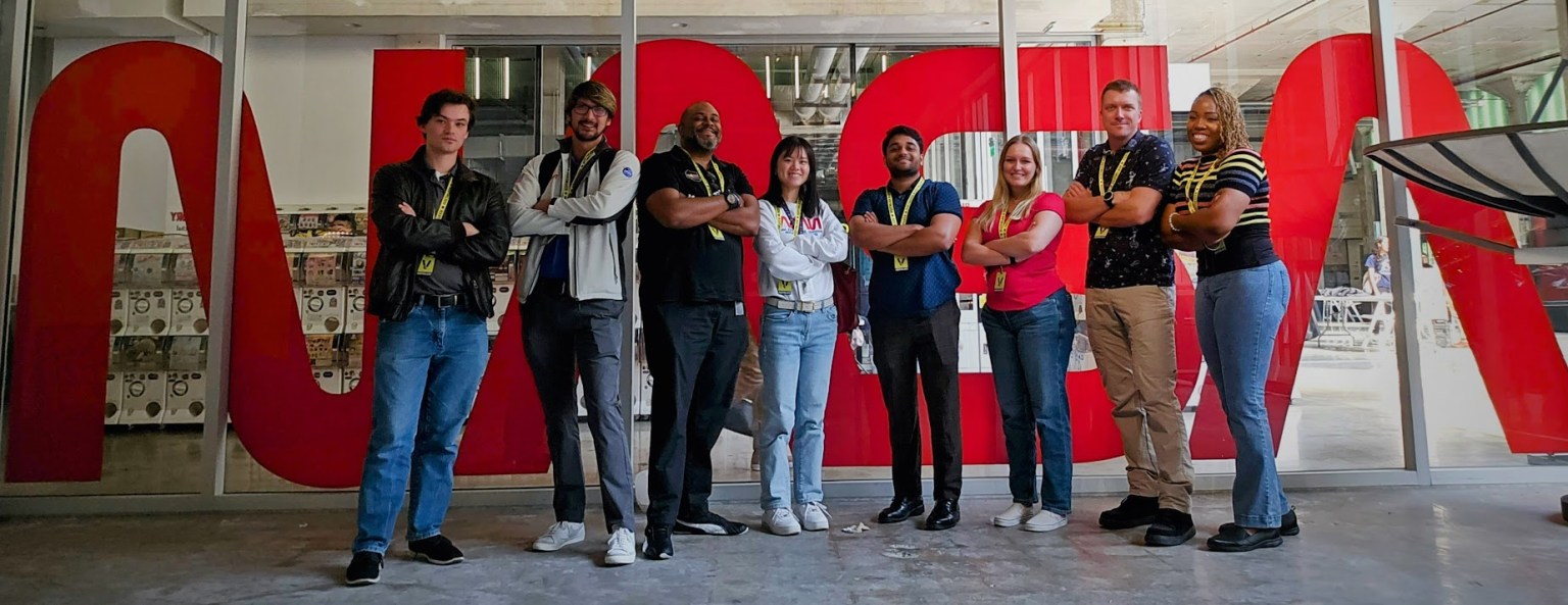
For NASA interns Kim Alexander and Ashley Rodriguez, NCAS became an unexpected springboard from community college to new careers.
After eight years as a bartender, Alexander was looking for a way to launch her career. She enrolled at Riverside Community College in Riverside, California, originally intending to pursue graphic design – but fell in love with math instead. Alexander participated in NCAS hoping it would look good on her resume and university transfer application. She ended up on a winning team that designed a human mission to Mars. The experience influenced her entire career trajectory.
“I was just completely overwhelmed by how amazing the program was,” said Alexander, who went on to participate in other NASA student opportunities. “But NCAS was the most monumental, because I really started thinking, ‘Hey, I could pursue a career in this. This is feasible.’”
Rodriguez grew up in South Florida, where she watched space shuttle launches but never considered a career at NASA. Instead, she gained experience in various roles and was parenting a toddler by the time she went back to school at Miami-Dade Community College seeking an IT degree. That’s where she first heard about NCAS, which ultimately set her on a path to a career in strategic communications.

Ashley Rodriguez
NASA Intern
The experience showed her the importance of strategic communications at NASA and helped her to discover a field she enjoys.
In January 2024, Rodriguez and Alexander started NCAS-funded NASA internships in the agency’s Aerosciences Evaluation and Test Capabilities Portfolio Office, where they met their mentor, Data and Analytics Manager Erik Lopez.
Today, both have earned university degrees and are starting NASA Pathways internships that could lead directly to full-time NASA employment. Rodriguez is working as a strategic communications intern in the Engineering Performance Management Office at the agency’s Kennedy Space Center in Florida, while Alexander is beginning an engineering role supporting the Flight Demonstrations and Capabilities Project at the agency’s Armstrong Flight Research Center in Edwards, California.
“They were the first two NCAS alumni interns; they literally onboarded together,” Lopez said. “And the fact that they now both get to come back to the agency as Pathways interns just brings me so much joy.”
Stories like Alexander’s and Rodriguez’s illustrate the impact NCAS can have, and underscore why the program’s updated mission aims to reach even more community college students.
This school year, NCAS is launching with a two-part mission. The cohort phase, which runs through fall, calls on students to participate in live virtual experiences with NASA experts and submit materials detailing a connection between their current coursework and a role at NASA. Faculty members are key to encouraging students who might not envision themselves in a NASA role. Up to 1,000 submissions will be eligible for a $500 award.
Those who successfully complete this phase will be invited to take part in the next phase, a spring virtual NCAS career fair linking them to experts and industry career opportunities. Upon completion of the career fair, students may submit additional materials for prizes of $250, for up to 500 of the top submissions.
Alicia Baturoni Cortez
Project Manager, NASA’s Minority University Research and Education Project
To explore NCAS timelines and eligibility requirements and take your education to the next level, visit: https://nasa-ncas.org/student-overview/.
Source: www.nasa.gov
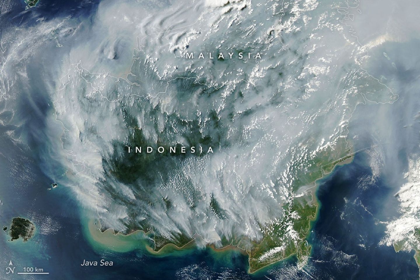
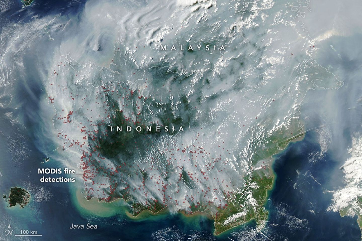
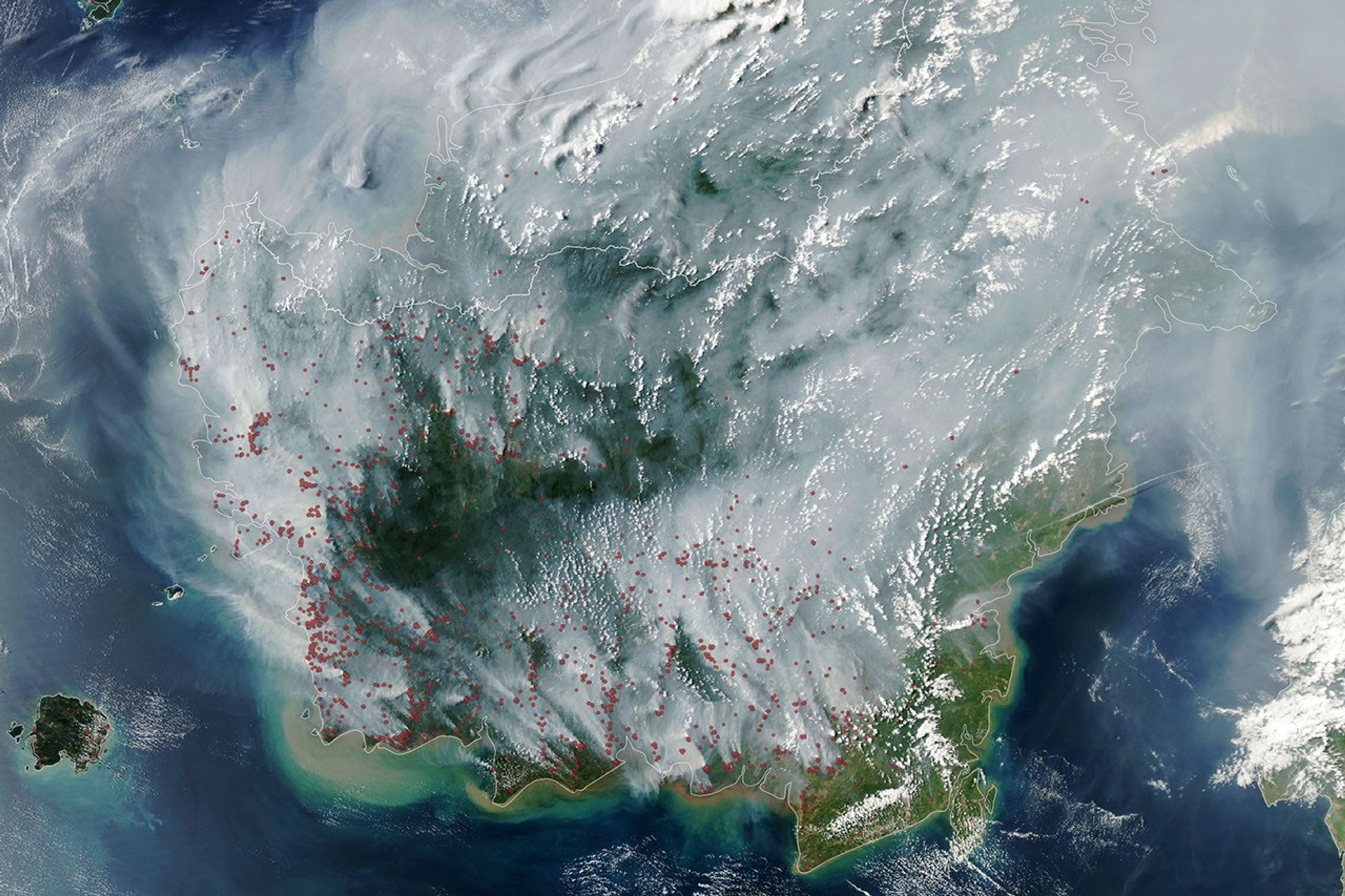
If there were an apex predator among fires, tropical peatland fires would be a top contender. These fires, which burn in dried wetland soils, are slow-burning, highly polluting, and notoriously difficult to extinguish because they smolder at low temperatures and often burn underground through expansive deposits of peat. By one estimate, peat fires generate three times more fine particulate matter than other tropical forest fires, five times more sulfur dioxide, three times more organic carbon, and two times more methane and carbon monoxide.
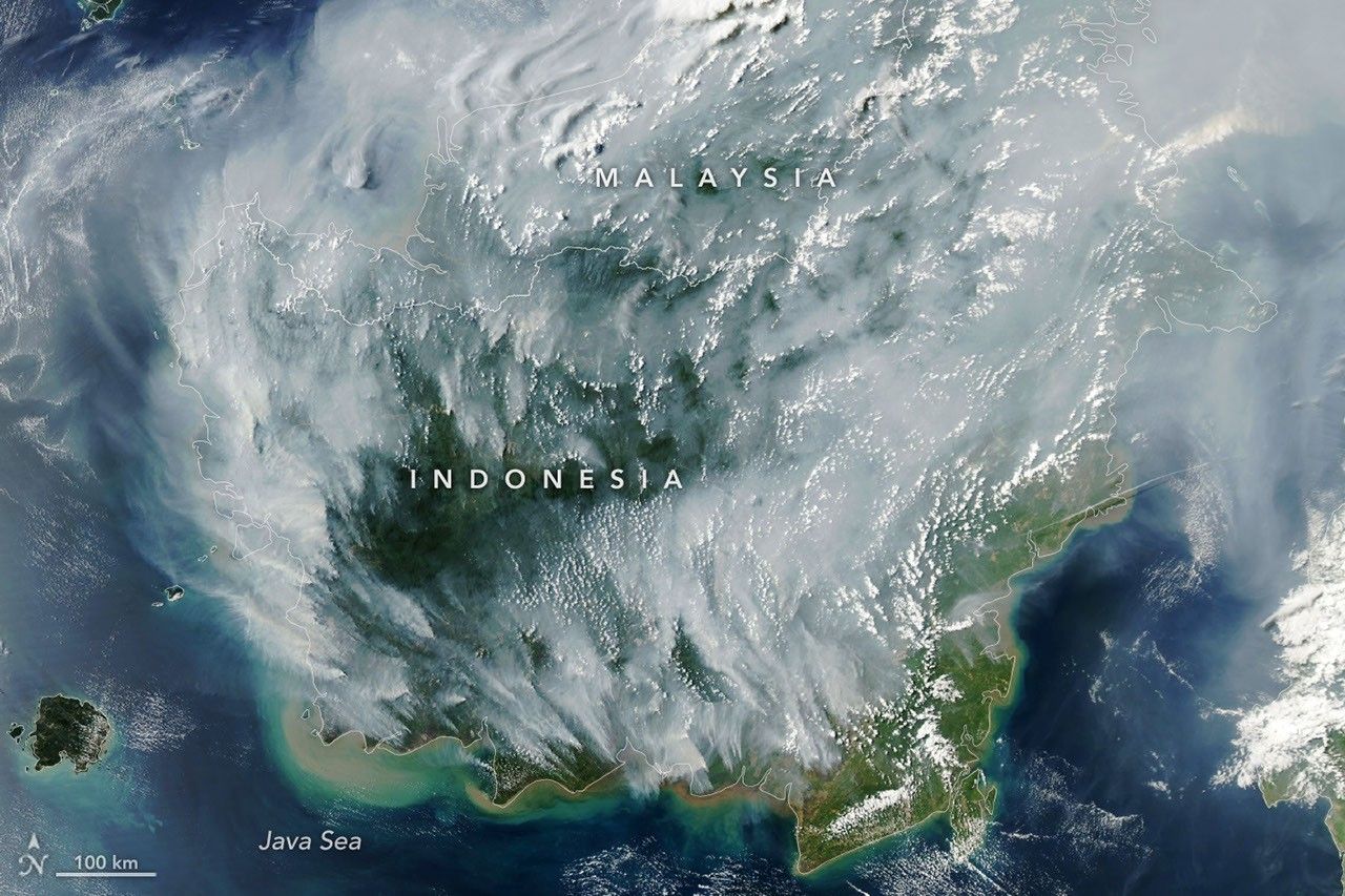
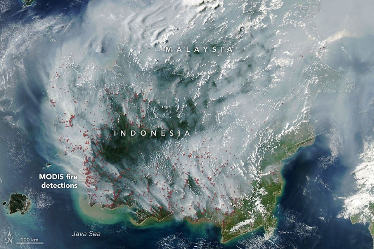
Fire season was underway in Indonesia when the MODIS (Moderate Resolution Imaging Spectroradiometer) on NASA’s Aqua satellite captured this image on September 1, 2026. In the map on the right, each red dot depicts one “fire detection.” A fire detection is a pixel in which the sensor and an algorithm determined there were thermal anomalies indicative of fire. Multiple detections can be generated by a single fire.
Peat fires are a recurring challenge in Indonesia, which is home to about 36 percent of the world’s tropical peatlands. When parched by drought, the archipelago’s peat landscapes have become unrelenting infernos on several occasions over the past three decades, with fires producing blankets of smoke for weeks on end and upending daily life for millions of people.
While fires occur in Indonesia every year, previous El Niño years—1997 and 2015 especially—produced the most extreme burning in recent decades. The climate pattern, assessed by NOAA as present and strengthening in August, typically leads to sharp reductions in rainfall in Indonesia, particularly when combined with a positive phase of the Indian Ocean Dipole, which was also present.
“Indonesia is only about three weeks into its fire season, but we’re seeing fire activity track sharply upward, similar to 2015,” said Robert Field, a Columbia University researcher who developed a tool called the Global Fire Weather Database that produces experimental, real-time fire weather forecasts. “The strong El Niño is making the dry season drier over the fire-prone parts of the country and exacerbating burning—just as we anticipated it would,” he said. In 2015, after burning for more than three months, Indonesia’s fires had released 1.75 billion tons of greenhouse gas equivalents—more than Japan emits in a year. As of September 2, Indonesia’s 2026 fires, having burned for about a month, have released roughly 10 percent as much as the 2015 fires.
As in 2015, Indonesia was in the midst of a severe and widespread drought in summer 2026. About 90 percent of the country received little to no rainfall in early August, according to data from the Indonesian meteorological agency. Normally, it’s too wet for fires to spread through underground peat deposits in Kalimantan, Sumatra, and Papua, but they can in dry conditions. “Surface fires are less of a concern, but when fires get underground, they just won’t stop,” Field said. “They’ll keep burning until the rains come in October or November.”
The Indonesian government uses NASA and NOAA observations from the MODIS and VIIRS sensors to track active fires in near-real-time. Indonesia’s Ministry of Forestry MODIS- and VIIRS-based fire-monitoring platform SiPongi, for instance, tallied 946 hotspots on August 31, 2026.
However, it’s difficult for MODIS and VIIRS to detect fires through thick smoke or clouds, within the forest understory, or underground in peat deposits. When Indonesian fires become the most intense, the number of fires recorded by VIIRS or MODIS can actually decrease. “The worst smoke events, paradoxically, can be the hardest to observe from space with MODIS and VIIRS,” said Mark Cochrane, an ecologist at the University of Maryland Center for Environmental Science who has conducted field research on peat fires in Indonesia for nearly a decade.
The large-scale construction of irrigation canals and drainage of peat swamps in the 1990s, part of an effort to establish massive rice farms, contributed to the flammability of the region today by significantly lowering the water table in wetland areas, Cochrane said. He also noted that oil palm and other plantation forestry is common in this region. Yet after an unusually grim fire season in 2015, governments and other organizations have worked to dam up some irrigation canals and restore wetlands. There have also been renewed efforts to improve firefighting capacity and reduce the number of fires that people accidentally ignite.
“This year will be a real stress test of the measures that were put in place after 2015,” said Shi Jun Wee, a University of Maryland graduate student. Wee is working on a team partnering with NASA and MapBiomas to develop new algorithms and techniques to detect more understory fires than MODIS and VIIRS can by tapping into shortwave infrared observations from Landsat and Sentinel-2 satellites. As the fires progress, he plans to track developments using NASA’s Worldview data browser, FIRMS (Fire Information for Resource Management System), HLS (Harmonized Landsat and Sentinel-2) observations, and GFED (Global Fire Emissions Database).
On the ground in Indonesia and neighboring countries, the smoke is already causing widespread disruptions. Indonesian officials have warned that large swaths of the population have been exposed to hazardous smoke. Some schools started shifting to remote learning, nine national parks have closed, and several flights have been delayed due to heavy smoke, according to news reports.
“People tend to focus on these fires during an El Niño and then forget about them,” Cochrane said. “We need sustained focus, even during the years when they aren’t as bad, to solve this,” he said. “These fires create a tremendous amount of emissions.”
NASA Earth Observatory image by Lauren Dauphin, using MODIS data from NASA EOSDIS LANCE and GIBS/Worldview. Story by Adam Voiland.
Stay up-to-date with the latest content from NASA as we explore the universe and discover more about our home planet.

In fire-prone ecosystems in Australia’s Northern Territory, prescribed burns are lit to minimize the severity of fires later in the…

Wildland fires in early August 2026 pushed air quality to unhealthy levels, destroyed hundreds of structures, and triggered mandatory evacuations…

The blaze burned more than 150 square miles and swept through parts of a ski resort.
Source: science.nasa.gov
APOD
Astronomy Picture of the Day
Discover the cosmos! Each day a different image or photograph of our fascinating universe is featured, along with a brief explanation written by a professional astronomer.
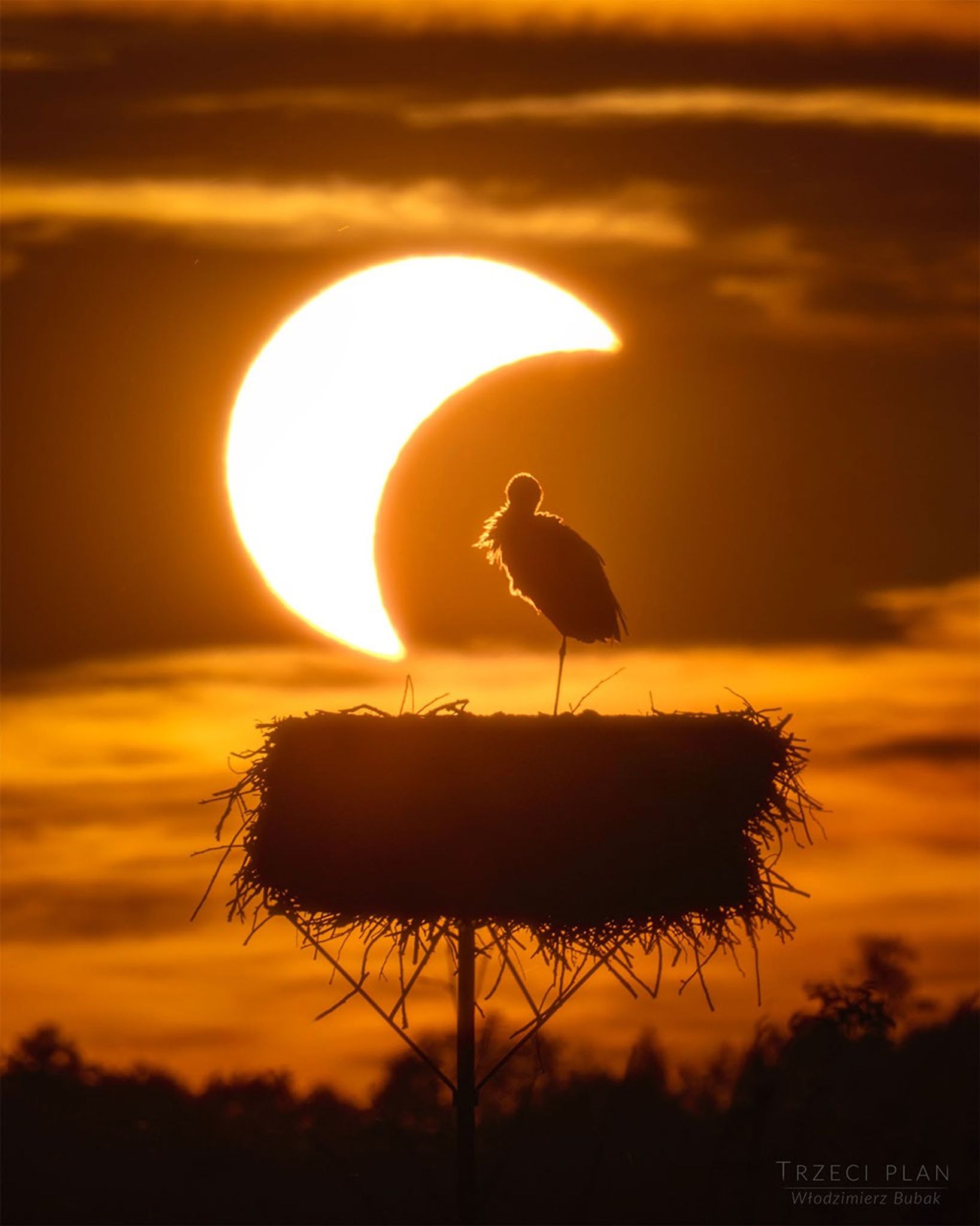
Explanation: How do animals react to a total solar eclipse? The featured image shows a stork roosting on her nest in Poland at a partial phase of the recent total solar eclipse. If you are lucky enough to experience a total eclipse somewhere quiet and close to nature, you may be able to notice unusual daytime animal behaviors. During totality, you may hear nighttime sounds like crickets and frogs and see fireflies. In the dark, most birds are quiet. Thinking that it is time to go to bed, ducks and other waterfowl prepare to sleep on one leg, with their heads turned around and their beaks tucked into their back feathers (they don’t really sleep with their heads tucked under one wing). When sunlight returns at the end of totality, songbirds greet the new “morning” with their dawn songs. The crickets and frogs go quiet again. Animals and people resume their lives, only briefly disturbed by the chance alignment of our Sun and Moon.
APOD’s main NASA site is moving : From apod.nasa.gov to science.nasa.gov/apod
Tomorrow’s picture: aloha
| Date | September 3, 2026 |
|---|---|
| Credit & Copyright | Włodzimierz Bubak |
| Authors & editors: | Cecilia Chirenti, Robert Nemiroff, Jerry Bonnell, Keighley Rockcliffe |
| A service of: |
ASD at NASA / GSFC, NASA Science Activation & Michigan Tech. U. |
Source: science.nasa.gov
3 min read
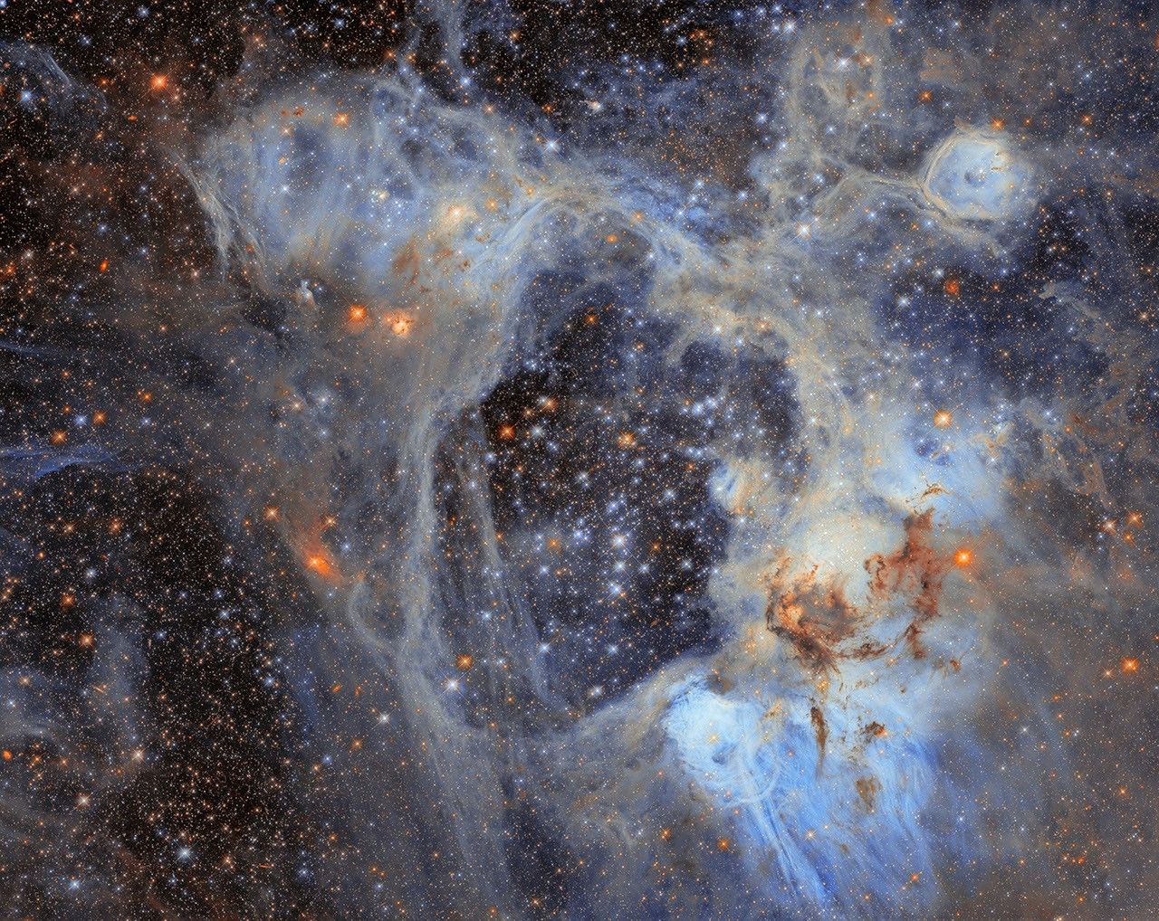
This NASA/ESA Hubble Space Telescope image features a sprawling cosmic vista in the Large Magellanic Cloud, or LMC, the largest of the small galaxies that orbit our Milky Way galaxy. At just 160,000 light-years away, the LMC offers a close look at highly active star birth sites like the one in this image. This photogenic nebula, named LHA 120-N44, or N44, is in the constellation Dorado.
N44 is dominated by two features: a vast central void and a shell of dense, dusty gas. The central void is a ‘superbubble’ spanning roughly 210 by 140 light-years across. The glittering stars at the center of the void are responsible for its creation; through their powerful stellar winds and explosive supernovae, these stars expelled much of the gas from which they were born.
When the stars of N44’s central star cluster swept away this gas, the expelled gas compressed and formed a shell around the superbubble. New stars are forming in this compressed gas shell, making N44 an interesting target for astronomers who are using the nebula to study how stars form in this environment. Their goal is to understand how long it takes from the collapse of cold gas clouds into dense knots to the moment nuclear fusion ignites in the heart of a newborn star.
The data in this image is from an observing program (#14689; PI: Gouliermis) that used Hubble to survey N44 and take a census of its stars, cataloging nearly half a million stars within the cluster as well as interlopers drifting in front of it. Of the stars surveyed, nearly 30,000 are what astronomers call pre-main-sequence stars, which have yet to begin fusing hydrogen into helium in their cores. Astronomers discovered this treasure trove of baby stars thanks to the high sensitivity and fine spatial resolution of Hubble’s instruments that can pick out faint objects in crowded clusters.
The gas shell surrounding the superbubble is energized by ultraviolet radiation from massive stars, causing it to glow and highlighting several distinct features. Each feature within the broader N44 star-forming complex was cataloged by astronomer Karl Henize in the 1950s. One feature is a smaller bubble, cataloged as N44F, that is located near the upper-right corner of this image. N44F is an interstellar bubble blown by the intense stellar winds of a single hot and massive star. As this previously released Hubble closeup shows, the star’s furious winds and radiation have sculpted the surrounding bubble and created pillars of dusty gas.
Hubble’s sensitive observations of the lowest-mass stars in this region open a new window onto star formation in regions that, like the LMC or the galaxies in the early universe, are poor in elements heavier than helium.
Text Credit: ESA/Hubble
Media Contact:
Claire Andreoli
NASA’s Goddard Space Flight Center, Greenbelt, MD
[email protected]
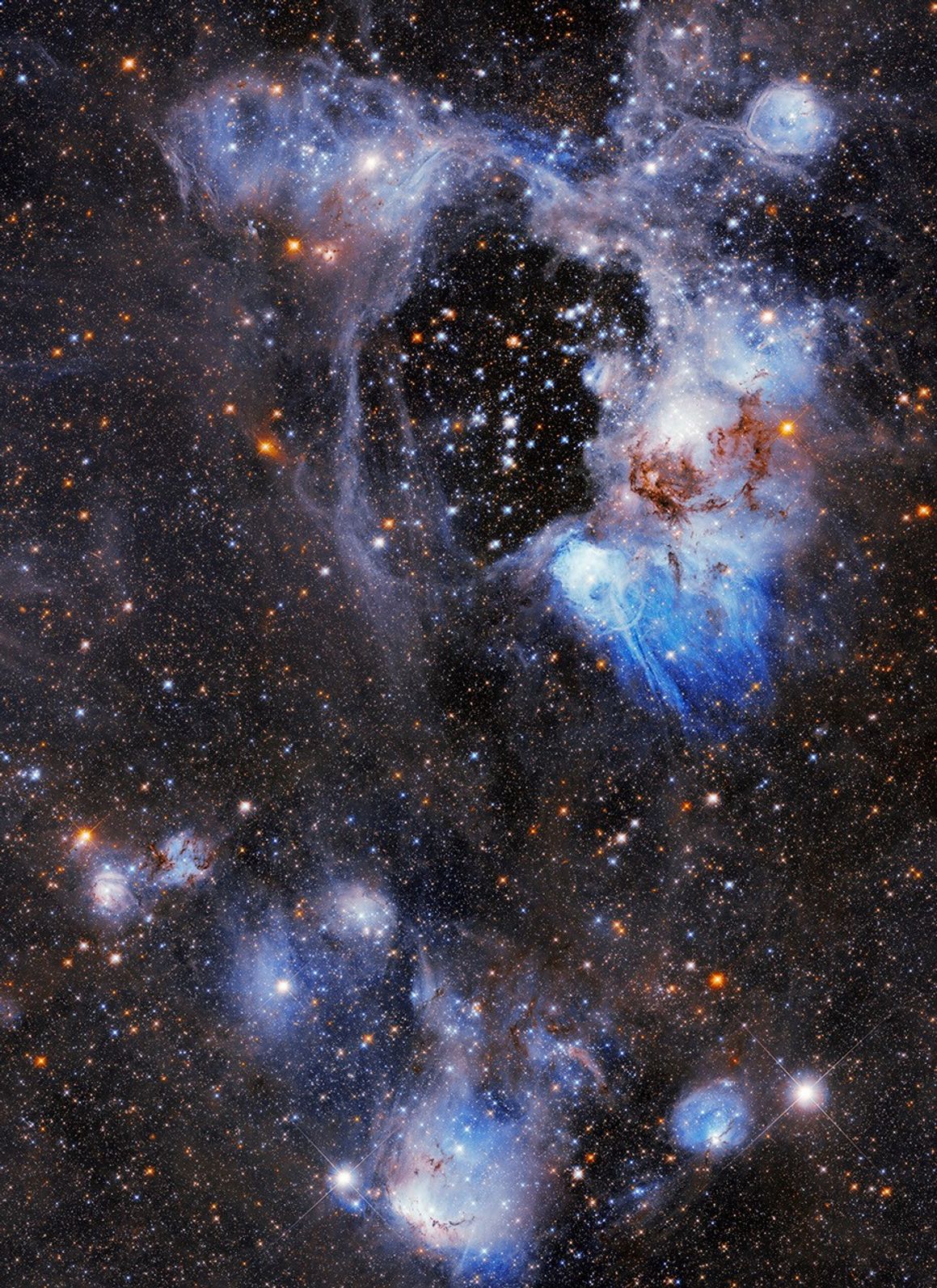
N44 is a complex nebula filled with glowing hydrogen gas, dark lanes of dust, massive stars, and many populations of stars of different ages. One of its most distinctive features, however, is the dark, starry gap called a “superbubble,” visible in this Hubble image in the upper central region.
Source: science.nasa.gov
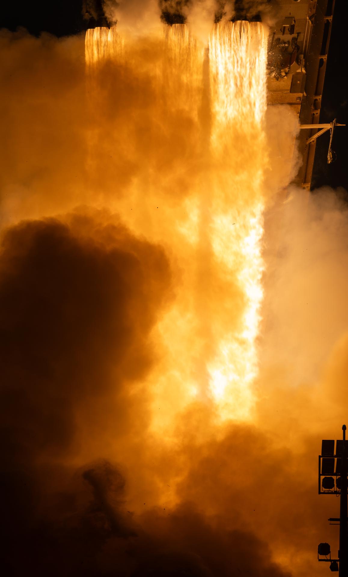
Now on a three-month, million-mile journey to its final orbit, NASA’s Nancy Grace Roman Space Telescope will soon reveal the universe’s darkest secrets. The mission launched at 7:26 a.m. EDT on Aug. 30 aboard a SpaceX Falcon Heavy rocket from Launch Complex 39A at the agency’s Kennedy Space Center in Florida.
Roman pairs a large field of view with crisp infrared vision to explore vast swaths of the sky and probe deeply into cosmic history. This flagship mission will help astronomers explore dark matter, dark energy, and worlds outside of our solar system, known as exoplanets.
Roman is the fourth primary mission NASA has launched on a Falcon Heavy rocket. Earlier this year, the agency’s Launch Services Program worked with SpaceX to accelerate the launch date to accommodate the space telescope’s early completion.
Source: www.nasa.gov